About
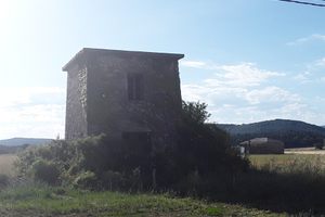
The Central Hidroeléctrica de la Horadada, is historic hydroelectric plant that once harnessed the flow of the Pisuerga River near to Mave in the north of the Palencia region of Spain, near the border with Cantabria. It was converted to a hydoelectric plant in the early 20th century and contributed to the local electricity supply until the Spanish government changed to a more centralised system based on much larger power plants. It sits in the Canyon de la Horadada along which runs a hiking trail through the canyon, past the historic building, then up to the plateau known as Las Tuerces a protected natural area and important Bronze age archeological site.
The hydoelectric plant is in a, whitewashed, four storey former water powered flour mill complex and is sometimes described as a "run of the river" hydroelectric system. This might be disputed since the water level is artificially raised by a weir and water was abstracted from the river.
The trail to the power plant and beyond starts at the parking lot at the trailhead which is on a well signposted, 400m long side road near to the junction of the local roads PP-6210 and PP-6200. The first part of the trail passes near to the river along the canyon which was formed by erosion of the upper Cretaceous limestone. The canyon so formed has been termed the Spanish Colorado
On passing the weir in the river the "oficial" trail contines along the river for about 1200 m then turns NE up a relatively gentle slope to a point close to the settlement of Villaescusa de las Tortes (after passing an archaeological site close to the river). Here it meets path crossing roughly E-W (shown in blue on the map on the info point at the parking lot). At this point your fitness will determine your next move as following this path E will involve very strenuous climbing up to the plateau with about 100m of ascent over 200m of path. It may be time to turn around and retrace your steps. following the path up to the plateau puts you onto a loop around the northern section of the Las Tuerces mountain. Several other, often even more challenging, routes are available but whatever you choose the hard work getting to the top will be rewarded with amazing views and a geological wonderland of karstic erosion features at the top known as the Las Tuerces Labarynth. Most routes require descent back to the Canyon but at least one recommends ascending the other side and returning on the west side of the river. This makes the walk very strenuous and should not be taken lightly. The gentle stroll along the east side of the river on the red trail rewards you with different canyon views as you are going in the opposite direction. An amazing hike with a lot to offer almost any level of fitness.
Community Contributors

Added By
Published
June 17, 2026