Places Foods Stories Newsletters
Loading...
Loading...
Loading...

No search results found for
“”

Make sure words are spelled correctly.

Try searching for a travel destination.

Places near me Random place

Popular Destinations

  • Paris
  • London
  • New York
  • Berlin
  • Rome
  • Los Angeles
Places Foods Stories Newsletters
Sign In Join
Places near me Random place
All the United States Pennsylvania Conewago Potholes
AO Edited

Conewago Potholes

These unique rock formations were created during the Ice Age.

Bainbridge, Pennsylvania

O Octomagi profile photo
Added By
Octomagi
Email
Been Here
Want to go
Added to list
CAPTION
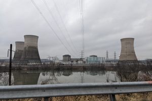
Conewago Potholes   Octomagi / Atlas Obscura User
Been Here
Want to go
Added to list

About

Located in the Susquehanna River, just south of Three Mile Island is the Conewago Potholes, a prehistoric diabase formation that eroded over the centuries.

The meltwater from the Ice Age created rapids that picked up sediment and drilled natural holes into the rock with underwater whirlpools. The remaining boulders, and subsequently the remaining potholes, are quite large—several large enough to fit a person.

The address to access the potholes is for the Falmouth Boat Launch, head to the river and start walking up the riverbed north towards Three Mile Island. Otherwise, visitors can bring a kayak to navigate the potholes, and paddle up towards the York Haven Dam.

The potholes are also a popular fishing spot for smallmouth bass and catfish. 

Places

Discover your next amazing Atlas Place.

Get more unusual and extraordinary places each week with the Atlas Obscura Places newsletter.

Your newsletter subscriptions with us are subject to Atlas Obscura's Privacy Policy and Terms of Use.

Related Tags

Water Prehistoric Natural Wonders

Know Before You Go

Be sure to check the water levels before going on the USGS page for water data for Harrisburg, you'll want the river level to be below 3.5 feet. Another colloquial name for the potholes is "the hunger rocks," because they're most visible during periods of drought. The best times to visit would be late summer or early fall, especially when there has been little rain.

Wear comfortable shoes for climbing up and over boulders, as well as sunscreen and drinking water, especially if you plan on moving up the riverbed to explore the rocks. 

Community Contributors

O Octomagi profile photo

Added By

Octomagi

R rlgartside profile photo

Edited By

rlgartside

  • R rlgartside profile photo rlgartside

Published

August 23, 2022

Edit this listing

Make an Edit
Add Photos
Conewago Potholes
111 Collins Rd
Bainbridge, Pennsylvania, 17502
United States
40.119132, -76.709159
Get Directions

Nearby Places

Three Mile Island Historical Marker

Middletown, Pennsylvania

miles away

The White Cliffs of Conoy

Marietta, Pennsylvania

miles away

Weightlifting Hall of Fame

York, Pennsylvania

miles away

Explore the Destination Guide

Photo of Pennsylvania

Pennsylvania

United States

Places 535
Stories 28

Related Places

  • Naruto Strait and its famed whirlpools

    Naruto, Japan

    Naruto Whirlpools

    The famed natural wonder that gave its name to a fishcake as well as one of the most popular anime series of all time.

  • Pointe de la Jonction

    Geneva, Switzerland

    Pointe de la Jonction

    Where two rivers meet—but don’t mix.

  • Heinabergslón

    Iceland

    Heinabergslón

    A little-known, yet charming glacial lagoon.

  • Boat in the khors of Oman

    Khasab, Oman

    The Desert Fjords of Oman

    Take the most scenic fjord landscape in Norway and add dramatic red cliffs, warm clear water, and playful dolphins.

  • Thermal Spring Cascades

    Hot Springs, Arkansas

    Thermal Spring Cascades

    Two gushing waterfalls of hot spring water within a block of each other.

  • Quedas de Calandula

    Calandula, Angola

    Quedas de Calandula

    This horseshoe-shaped waterfall is the second-largest on the African continent.

  • Old Perpetual Geyser

    Lakeview, Oregon

    Old Perpetual Geyser

    Along the Outback Scenic Byway, adjacent to hot springs, this human-made geothermal feature takes unexplained breaks.

  • Poza Azul the end view.

    Cuatrociénegas, Mexico

    Poza Azul

    A spectrum of colors awaits visitors to one of Mexico's most gorgeous bodies of water.

Aerial image of Vietnam, displaying the picturesque rice terraces, characterized by their layered, verdant fields.
Atlas Obscura Membership

Become an Atlas Obscura Member


Join our community of curious explorers.

Become a Member

Get Our Email Newsletter

Follow Us

Facebook YouTube TikTok Instagram Pinterest RSS Feed

Get the app

Download the App
Download on the Apple App Store Get it on Google Play
  • All Places
  • Latest Places
  • Most Popular
  • Places to Eat
  • Random
  • Nearby
  • Add a Place
  • Stories
  • Food & Drink
  • Itineraries
  • Lists
  • Video
  • Podcast
  • Newsletters
  • All Trips
  • Membership
  • Feedback & Ideas
  • Community Guidelines
  • Product Blog
  • Unique Gifts
  • Work With Us
  • About
  • FAQ
  • Advertise With Us
  • Advertising Guidelines
  • Privacy Policy
  • Cookie Policy
  • Terms of Use
Atlas Obscura

© 2026 Atlas Obscura. All Rights Reserved.