About
Delaware and Pennsylvania boast the only semi-circular state line in the United States. However, at the western end, the semi-circle is cut off just before the Mason-Dixon Line. This results in a tiny piece of land jutting out from Delaware's otherwise smooth border. This little wedge of land would fit even less neatly in Pennsylvania, yet the two states both claimed it up until 1921.
As with other state line anomalies, such as the Southwick Jog between Connecticut and Massachusetts, the imperfections of surveyors trying to draw neat lines through previously indistinguishable lands are to blame. When Pennsylvania, Delaware, and Maryland were first established as colonies in the 17th century, their boundaries were poorly defined and not demarcated until the 1760s. In 1763, the Calvert family, who ruled Maryland, and the Penn family, who controlled Pennsylvania and Delaware, agreed on the Mason-Dixon Line as the border between their lands. A segment of the Twelve-Mile Circle—so named because it had a radius of twelve miles with Delaware's then-capital New Castle at its center—became the boundary between Pennsylvania and Delaware.
Unbeknownst to colonial authorities, however, a square mile was in between the Twelve-Mile Circle and the two perpendicular portions of the Mason-Dixon Line. This was not an issue while both states were under common rulership of the Penns. At first, largely a lawless "no-man's land," the territory came under Delawarean control because they had more convenient access to it. However, the dispute flared up in 1849 when the U.S. Army Corps of Topographical Engineers resurveyed Maryland's northeast corner. The monument they placed there affirms the wedge as part of Pennsylvania, a claim that state pressed, but Delaware ignored.
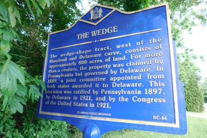
Ownership was not ruled upon until 1889, when a joint commission of the two states affirmed that the wedge was in Delaware. Although federal surveyors demarcated the border several years later, the dispute was not yet resolved as neither state bothered to ratify the decision. In fact, some USGS maps from this period still showed the wedge in Pennsylvania. Pennsylvania held out until 1897, and Delaware ironically did not ratify the wedge for over a hundred-year-long dispute for good. Ratification and Congressional recognition finally ended the over hundred-year-long dispute for good.
Today, the Delaware Wedge merely appears to be another periurban part of Delaware. If it were not for the plaque commemorating the dispute, one would not notice anything off about the territory. This has not stopped some from making light of the former dispute, however. In 2021, for example, New Castle County teasingly offered the wedge back to Pennsylvania as an April Fools' Day joke.
Community Contributors
Added By
Published
June 19, 2026