About
Mullicourt aqueduct is close to Outwell in the Cambridgeshire Fens. It is in the area of England now known as East Anglia, comprising Parts of Lincolnshire, Norfolk, Suffolk, Cambridgeshire and Essex. This was the southern and eastern part of the land settled (in the 5th Century) by the Germanic tribe, the Angles. In fact the fen area was, itself not settled by the invaders. At the time considered to be unproductive marsh. The isolated dry islands became the refuge of numerous religious hermits and, after the Norman conquest, the rebels led by Hereward the Wake.
It was the draining of this extensive marsh, to form highly productive, agricultural land which gave rise to the need for the aqueduct. Despite the fact that the Wisbech canal closed in 1922 the commercial traffic on Well Creek continued until the 1960s and nowadays it plays an important role for leisure craft.
The drainage of the fens is a long and complicated story, starting as early as the middle ages, blossoming in the 17th century with the construction, by Cornelius Vermuyden, of a massive drain called the Old Bedford River, just before the English Civil War and then the New Bedford River, just after the Civil War. These two drains ran parallel and between them was created a massive flood storage reservoir to store water in times of flood. After several setbacks the drainage of the fens was essentially thought to be completed in the 20th century including the final version of the Denver Sluice complex (https://www.atlasobscura.com/places/the-denver-sluice-complex-denver-england )in the 1950s. This has resulted in the fens being considered the most productive agricultural land in the UK.
One of the important engineering features of the effort to drain the fens was the redirection of the River Nene from Peterborough to form a straighter course and to outfall at the sea via Wisbech. The old course of the Nene became known as Well Creek and it became an important inland waterway, particularly when the Wisbech Canal connected it to the new course of the Nene at Wisbech. A major function was to carry coal to the many steam powered pumping stations which were rapidly replacing wind driven pumps. When the drainage needed to be improved further in the 18th century a massive additional drainage channel , called the Middle Level Drain was dug from Three Holes to discharge into the River Great Ouse at Wiggenhall St Germans , crossing the path of Well Creek.
The drainage efforts that had been made over the previous 500 or so years had resulted in the shrinkage of the peat based soils. The rate of soil shrinkage through both erosion and consolidation is very significant. At nearby Holm Fen this has been demonstrated by driving metal posts into the soil and cutting them off at ground level in 1848. The images speak for themselves. Thus shrinkage of the land resulted in natural river levels much higher than the land to be drained and drainage channels needed to be excavated such that water can drain into them under gravity with pumps now required to get water from the artificial drains into the natural rivers. The water level in the Middle Level Drain is currently some 2 metres below that in the natural channel of Well Creek.
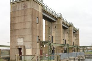
The requirement to maintain navigation in Well Creek resulted in the need for an aqueduct. The 1848 version was replaced with a steel trough based structure in 1921 (when a new sluice gate was also installed). There is only about a foot of headroom from the surface of the Middle Level Drain to the lowest point of the structural steelwork on the aqueduct. This means that Mullicourt aqueduct is the furthest limit of Navigation on the Middle Level Drain, beyond this point it carries water to St Germans as part of its drainage function. The Mullicourt aqueduct is the only navigable aqueduct in East Anglia.
Community Contributors

Added By
Published
May 21, 2026