Places Foods Stories Newsletters
Loading...
Loading...
Loading...

No search results found for
“”

Make sure words are spelled correctly.

Try searching for a travel destination.

Places near me Random place

Popular Destinations

  • Paris
  • London
  • New York
  • Berlin
  • Rome
  • Los Angeles
Places Foods Stories Newsletters
Sign In Join
Places near me Random place
All the United States Minnesota Williams The Minnesota Forest

The Minnesota Forest

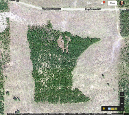
This Minnesota-shaped forest is actually located in the state it is shaped like.

Williams, Minnesota

EricGrundhauser profile photo
Added By
Eric Grundhauser
Email
Been Here
Want to go
Added to list
The Minnesota Forest   Google Maps
Add Photos
The Minnesota Forest   Google Maps
Been Here
Want to go
Added to list

About

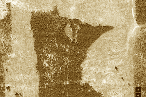
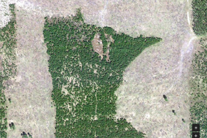
Only visible from the air, the carefully shaped copse of trees known simply as the "Minnesota Forest" has been shaped by a rogue forester over decades to look like its home state.

Created quietly by forest engineer Bill Lockner, the state-shaped forest was only recently discovered thanks to Google Maps aerial view for the everyman. While clearing dying pine trees in the early '90s Lockner took it upon himself to have a little fun, Forest Services-style. Using nothing more than a compass and other analog measurement tools, he was able to map out the shape of Minnesota in the trees and cleared out the dying growth only in the shape of the state. Photos from 1991 show a Minnesota-shaped hole in the surrounding forest.

Over the ensuing decades as the trees grew back, almost burying Lockner's art project as the surrounding forest blended in with it. Another round of clearing occurred in the 2000's, but this time the foresters cleared only the trees AROUND the Minnesota design, creating a smallish new forest that was shaped like the state as opposed to a clearing.

While Lockner modestly refuses to say much of anything about the Minnesota Forest, the whimsical grove has become a popular site on Google Maps.

Places

Discover your next amazing Atlas Place.

Get more unusual and extraordinary places each week with the Atlas Obscura Places newsletter.

Your newsletter subscriptions with us are subject to Atlas Obscura's Privacy Policy and Terms of Use.

Community Contributors

EricGrundhauser profile photo

Added By

EricGrundhauser

C cruiserbob profile photo

Edited By

cruiserbob

  • C cruiserbob profile photo cruiserbob

Published

April 21, 2014

Edit this listing

Make an Edit
Add Photos
Sources
  • http://blogs.citypages.com/blotter/2014/03/forest_shaped_minnesota_photo.php
  • http://blogs.citypages.com/blotter/2014/03/minnesota_shaped_forest_photos_google_earth.php

Related Tags

Forests Trees Shaped Forests Maps Ecosystems Plants
The Minnesota Forest
Stony Corners Trail SW
Williams, Minnesota, 56686
United States
48.55999, -94.932621
Get Directions

Nearby Places

Willie the Walleye

Baudette, Minnesota

miles away

Big Bog State Recreation Area

Waskish, Minnesota

miles away

Basshenge

Baudette, Minnesota

miles away

Explore the Destination Guide

Photo of Minnesota

Minnesota

United States

Places 204
Stories 26

Nearby Places

Willie the Walleye

Baudette, Minnesota

miles away

Big Bog State Recreation Area

Waskish, Minnesota

miles away

Basshenge

Baudette, Minnesota

miles away

Explore the Destination Guide

Photo of Minnesota

Minnesota

United States

Places 204
Stories 26

Related Stories and Lists

Seeking the (Minnesota-Shaped) Forest Through the Trees - Part 2

Podcast

By The Podcast Team

Seeking the (Minnesota-Shaped) Forest Through the Trees - Part 1

Podcast

By The Podcast Team

13 Marvelous Maps That Go Way Beyond Paper

List

By Kavya Ram Mohan

Related Places

  • Bosco Italia

    Norcia, Italy

    Bosco Italia

    A map of Italy made entirely of trees.

  • Luecke from satellite view

    Smithville, Texas

    Giant 'Luecke' Signature

    A Texas landowner spelled out his name with three miles of trees, a giant signature that's been used by NASA to evaluate satellite imagery.

  • (Flickr/Erik B)

    Anton Valley, Panama

    Valley of Square Trees

    Right angles in the forests of Panama.

  • The Enchanted Forest

    Whitethorn, California

    Enchanted Forest

    A grove of "candelabra redwoods" deep in California's Lost Coast.

  • Brea Redwood Grove

    Brea, California

    Brea Redwood Grove

    A non-native grove of 241 redwoods in Southern California.

  • The redwoods.

    Cabezón de la Sal, Spain

    Bosque De Secuoyas (Redwood Forest)

    An out-of-place grove of sequoias thrives in northern Spain.

  • Museum building and tool shop.

    Grayling, Michigan

    Hartwick Pines Logging Museum

    This museum in the woods evokes the work and lives of Michigan's 19-century lumberjacks.

  • The rounded base of an Eospermatopteris stump.

    Gilboa, New York

    Gilboa Fossils

    This Catskills museum preserves stumps from the earliest known fossil forest on Earth.

Aerial image of Vietnam, displaying the picturesque rice terraces, characterized by their layered, verdant fields.
Atlas Obscura Membership

Become an Atlas Obscura Member


Join our community of curious explorers.

Become a Member

Get Our Email Newsletter

Follow Us

Facebook YouTube TikTok Instagram Pinterest RSS Feed

Get the app

Download the App
Download on the Apple App Store Get it on Google Play
  • All Places
  • Latest Places
  • Most Popular
  • Places to Eat
  • Random
  • Nearby
  • Add a Place
  • Stories
  • Food & Drink
  • Itineraries
  • Lists
  • Video
  • Podcast
  • Newsletters
  • All Trips
  • Membership
  • Feedback & Ideas
  • Community Guidelines
  • Product Blog
  • Unique Gifts
  • Work With Us
  • About
  • FAQ
  • Advertise With Us
  • Advertising Guidelines
  • Privacy Policy
  • Cookie Policy
  • Terms of Use
Atlas Obscura

© 2026 Atlas Obscura. All Rights Reserved.