In Estonia, It’s Possible to Ski Across 20 Mountains in One Day
What started as a scientific expedition has turned into a wild tradition.
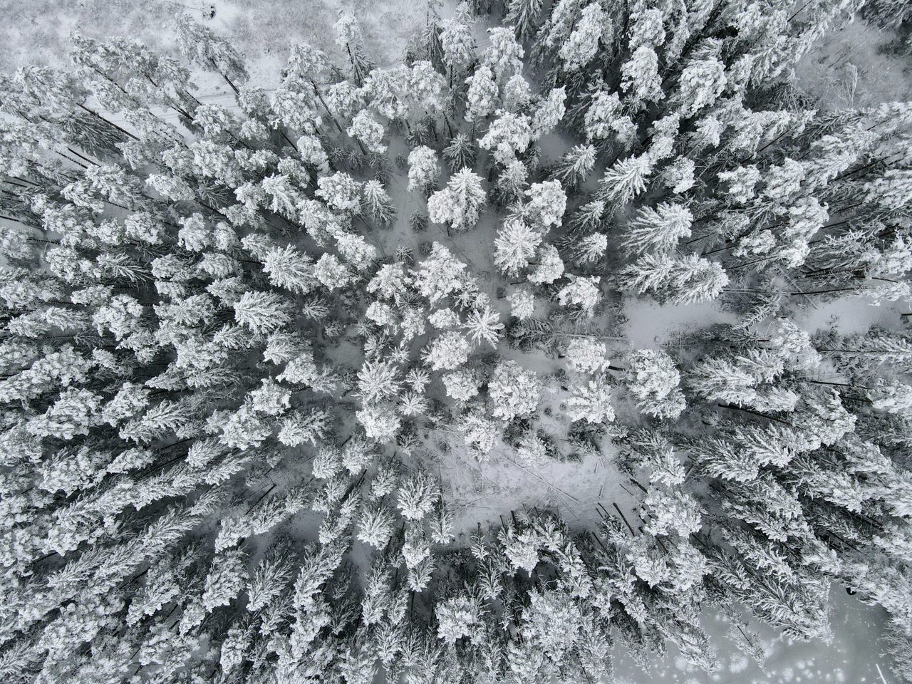
Standing on top of Suur Munamägi, the highest point of Estonia, Taavi Pae got a glimpse of what it must feel like to be a real mountaineer. Pae, the president of the Tartu Students’ Nature Conservation Circle, felt dog-tired after battling knee-deep snow, freezing temperatures, and the absence of proper trails. Together with 39 other students, he had just skied more than 25 kilometers (15 miles) in the country’s hilly south, climbing Estonia’s 20 highest peaks in the process. Suur Munamägi, or Big Egg Mountain, was the symbolic finish line.
“I’m not saying it felt like reaching the roof of the Himalayas, but still…” recounts Pae, who nowadays is an associate professor of Estonian Geography at the Tartu University.
Climbing the 20 mountains of Estonia in a single day is now a tradition today—and it all started with a geographer’s ambition to survey the peaks.

The year was 1998. As a budding geographer, Pae’s mind had just been blown by a new revelation. Vällamägi, the second highest mountain of Estonia, did not stand at 297 meters (974 feet), like he had always learned in school and read in an encyclopedia. Instead, Pae had actually just climbed 304 meters (997 feet) to the top—seven meters (23 feet) higher than previously thought.
“Nowadays we have LIDAR. But back then, it was quite problematic to measure heights,” says Pae. “In Soviet times, geographers based themselves on air photography, but forest cover complicated things.” Trees can hide the true relief of a hill, but LIDAR more accurately measures distances by emitting laser pulses. Hence, with technology getting better, heights changed over time.
Let’s be clear: Most of Estonia is flat as a pancake. Even the highlands of Haanja, a collection of moraines formed by retreating glaciers in the south of the country, are no Rockies or Andes by any stretch of the imagination. Suur Munamägi, as the tallest hill, stands at a modest 318 meters (1,043 feet). The country’s topography, though, actually presents a unique undertaking: It’s possible to scale all the highest points in Estonia in a single, long day hike. The 20 highest peaks—Estonian language defies international definitions and confidently calls each of them mägi, or mountain—are concentrated in a corridor about eight kilometers (five miles) long and two kilometers wide (a little over a mile).
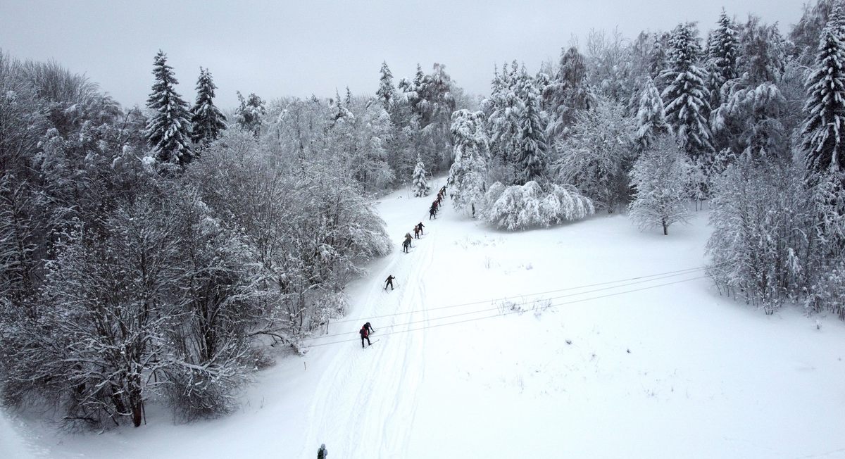
As the geography department of the Tartu University had just gotten their first GPS devices, Pae and his fellows decided to test the new technology and verify previous measurements. They plotted a plan to record more accurate data in the field. In an attempt to publicize the science behind measuring hills, they organized a press conference at the foot of Vällamägi. Then the forty students set out for exploration, armed with Soviet-era wooden skis, colorful winter clothes from thrift shops, and their new toys.
Old Soviet topographic maps were still classified, and no one had ever attempted the journey before, so they had to improvise. They connected roads with ski and snowmobile tracks, and often had to bushwhack and trailblaze their way to tops. “Looking back, I don’t know how we managed,” says Pae. “We had one map for forty people, that was it. Most students had never even seen a GPS before.”

Taking out their GPS devices and calibrating their altitude on each peak, Pae and his companions discovered “just a meter here and there” of inaccuracies. “To be honest, hand GPS devices back then were good at measuring latitude and longitude, but there was a significant margin of error for heights,” he explains.
Hence, Pae and a few fellow students returned to half a dozen of the mountains a few weeks later, this time not on skis but equipped with a more accurate scientific GPS. First, they carefully placed the device in an open area near the summit, ensuring an unobstructed line of sight to the mountain peak. This allowed them to make a precise measure of the height. Then they employed “good old” leveling techniques, measuring vertical angles to ascertain the accurate elevation of the mountain’s highest point.
Afterwards, Pae published his first articles: one on the science behind measuring Estonian mountains in the popular science magazine Eesti Loodus (Nature of Estonia); another in the cultural academic magazine Akadeemia, on the history of measuring said mountains.

The students then gave the challenge a name, saying that those who accomplished climbing all of Estonia’s mountains in one or two days, on skis or on foot, earned the title Lumeilves, or Snow Lynx. The name is a nod to the former Soviet Union’s Snow Leopard award, which recognized mountaineers bagging all of the USSR’s five mountains, each of which exceeds 7,000 meters (around 23,000 feet) in height.
Ever since that first conquest, the challenge has become an annual tradition and something of a rite of passage for local outdoor enthusiasts. People attempt the endeavor independently or as groups—in record years, up to 200 people have participated. Expedition leader Kunnar Karu has completed the hike fifteen times. Being from Estonia, he’s a mountaineer from a country without mountains. “We might not have mountains, but a good winter means lots of snow and low temperatures,” Karu says.
Only one of his journeys was snow-free. On one particular trek, the temperatures dropped to minus 24 degrees Celsius (minus 11 degrees Fahrenheit). “But that has certain advantages,” he says. “As a snack, we put ice cream in our backpacks.”

In all seriousness, Karu firmly believes that “if you can manage this hike, you can survive most mountain expeditions.” He should know. When he recently mounted Everest, he leaned on the skills honed through many years of Haanja expeditions. Trekking in Haanja involves navigating challenging terrain, steep ups and downs through thickets, and “bulldozing your way up,” says Karu.
“When the snow reaches higher than your knees, it can feel more like crawling or swimming,” he says. “It can be hard work, with lots of heavy breathing and changes in rhythm. That’s why Everest felt like coming home to me [and] doing the things I’ve been doing for years. Also, if the climb comes to an end in Estonia, it also has to end in the Himalayas.”
Despite his expeditions at higher altitudes, Karu still cherishes the Haanja excursions. “On clear days in winter, the landscape forms the Estonian flag: the sky, forest, and snow forging horizontal blue, black and white strips across the skyline,” Karu muses. “Stepping out of the deep forest and seeing that image is special to every Estonian.”

After completing the journey and heading back to civilization, most expeditions end in a sauna. In this part of the country, many of those are smoke saunas, which are filled with a fiery haze and are even used to smoke meat. After throwing water on the sizzling rocks and whisking their skin to stimulate circulation, the saunas are the perfect way to warm up stiff muscles.
Still, the Lumeilves begs the question: Did the expeditioners ever see a lynx during a snow lynx hike? Taavi Pae grins. “Never,” he says. “Lynxes are notoriously hard to spot. But they live in the area, so it must be possible.”


Follow us on Twitter to get the latest on the world's hidden wonders.
Like us on Facebook to get the latest on the world's hidden wonders.
Follow us on Twitter Like us on Facebook