Places Foods Stories Newsletters
Loading...
Loading...
Loading...

No search results found for
“”

Make sure words are spelled correctly.

Try searching for a travel destination.

Places near me Random place

Popular Destinations

  • Paris
  • London
  • New York
  • Berlin
  • Rome
  • Los Angeles
Places Foods Stories Newsletters
Sign In Join
Places near me Random place
All the United States Oregon Depoe Bay Cape Foulweather

Cape Foulweather

The first North American landing spot for James Cook on his third voyage of discovery in the Pacific.

Depoe Bay, Oregon

V Valleycat profile photo
Added By
Valleycat
Email
Been Here
Want to go
Added to list
CAPTION
Foulweather Lookout   Luz/CC BY 2.0
Cape Foulweather   Nicholas Wang/CC BY-SA 2.0
  Edmund Garman/CC BY 2.0
Looking south from Cape Foulweather   Barry McBeth/CC BY 2.0
Gift Shop   Tom Bridge/CC BY-ND 2.0
Cape Foulweather.   Valleycat / Atlas Obscura User
Been Here
Want to go
Added to list

About

Cape Foulweather sits about 500 feet above the Oregon coast on a basalt cliff overlooking whale-rich kelp beds. It was the first North American landing spot for Captain James Cook on his third voyage in the Pacific. Cook was widely known for his violent, tyrannical approach to the Indigenous people he encountered. 

Captain James Cook stumbled on the site on March 7, 1778. His journal entry from the day reads: "The land appeared to be of moderate height, diversified with hill and Valley and almost everywhere covered with wood. There was nothing remarkable about it except one hill.... At the northern extreme the land formed a point which I called Cape Foulweather from the very bad weather we soon after met with."

The region was inhabited by Native Americans including the Tillamook people, who traditionally lived in an area that extended from Tillamook Head in northwest Oregon to Cape Foulweather in the south.

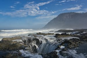
Cape Foulweather can be found near the Devil's Cauldron (the name of the nearby bay) and the Yaquina Head Lighthouse. The site, which is a popular tourist destination because of the beautiful scenery, consists of an open overlook and a small gift shop near the coast. When the weather turns bad—and it often does—visitors can take cover in the gift shop, which has cliff-side panoramic windows overlooking the water and kelp beds. 

The site is accessed by a winding tangle of roads connected to US 101. A small parking lot serves visitors. About two miles to the south, Beverly Beach State Park offers camping sites, yurts, full hook-ups for campers and trailers, a grocery store, and direct beach access.

Places

Discover your next amazing Atlas Place.

Get more unusual and extraordinary places each week with the Atlas Obscura Places newsletter.

Your newsletter subscriptions with us are subject to Atlas Obscura's Privacy Policy and Terms of Use.

Know Before You Go

Located approximately six miles north of Newport, Oregon, along coast route 101. Clearly marked by signs from either direction.

Community Contributors

V Valleycat profile photo

Added By

Valleycat

F finlayson profile photo M michellecassidy1 profile photo H heidimacdonald profile photo

Edited By

finlayson, michellecassidy1, heidimacdonald

  • F finlayson profile photo finlayson
  • M michellecassidy1 profile photo michellecassidy1
  • H heidimacdonald profile photo heidimacdonald

Published

March 30, 2011

Edit this listing

Make an Edit
Add Photos
Sources
  • Wikipedia: Cape Foulweather: http://en.wikipedia.org/wiki/Cape_Foulweather
  • Cape Foulweather, Oregon Coast: http://www.paulnoll.com/Oregon/Tourism/Coast-Lincoln-Walport/Noll-Cape-Foulweather-choices.html
  • Cape Foulweather's Look-Out Observatory & Gift Shop: http://www.oregoncoast101.com/recreation/cape_foulweather.htm
  • Oregon Parks & Recreation Department: Otter Crest State Scenic Viewpoint: http://www.oregonstateparks.org/park_224.php
  • Beach Connections: Exploring the Oregon Coast: Cape Foulweather and Cliffs: http://www.beachconnection.net/news/depoe071110_108.php
  • https://en.wikipedia.org/wiki/Third_voyage_of_James_Cook#Voyage

Related Tags

Water Dead Explorers Captain Cook Colonialism
Cape Foulweather
Depoe Bay
Lincoln County
Depoe Bay, Oregon, 97341
United States
44.808447, -124.063171
Visit Website
Get Directions

Nearby Places

Devils Punchbowl

Otter Rock, Oregon

miles away

Neskowin Ghost Forest

Neskowin, Oregon

miles away

Bazalgette the Whale

Yachats, Oregon

miles away

Explore the Destination Guide

Photo of Oregon

Oregon

United States

Places 230
Stories 33

Nearby Places

Devils Punchbowl

Otter Rock, Oregon

miles away

Neskowin Ghost Forest

Neskowin, Oregon

miles away

Bazalgette the Whale

Yachats, Oregon

miles away

Explore the Destination Guide

Photo of Oregon

Oregon

United States

Places 230
Stories 33

Related Places

  • Captain Cook Monument

    Kealakekua, Hawaii

    Captain Cook Monument

    A controversial memorial at the place where Captain Cook met his violent end.

  • Flora Fountain

    Mumbai, India

    Flora Fountain

    An iconic fountain dedicated to the Roman goddess Flora stands in the heart of Mumbai.

  • Espada Aqueduct

    San Antonio, Texas

    Espada Aqueduct

    Water still flows through the oldest Spanish aqueduct in America.

  • Underground reservoir

    San Juan, Philippines

    El Deposito Underground

    The largest Spanish artifact built in the Philippines and one of the oldest underground reservoirs in the world.

  • The aqueduct or what remains of it.

    San Juan, Philippines

    Arko San Juan

    The only remaining section of an aqueduct that used to supply water to Manila during the Spanish occupation.

  • Hang Li Poh’s Well (Perigi Raja)

    Malacca, Malaysia

    Hang Li Poh’s Well (Perigi Raja)

    Initially built for a Chinese princess and sultana, this well was used to secretly assassinate some 200 Portuguese colonizers.

  • Lt. James Cook Monument Cairn

    Seventeen Seventy, Australia

    Lt. James Cook Monument Cairn

    A cairn commemorating James Cook's second landing in Australia.

  • Tà Má Stream

    Vietnam

    Tà Má Stream

    Deep within the rugged mountains of Vinh Thanh, this crystal-clear stream meanders through a primeval forest of ancient wild ixora trees protected for generations by the local Ba Na community.

Aerial image of Vietnam, displaying the picturesque rice terraces, characterized by their layered, verdant fields.
Atlas Obscura Membership

Become an Atlas Obscura Member


Join our community of curious explorers.

Become a Member

Get Our Email Newsletter

Follow Us

Facebook YouTube TikTok Instagram Pinterest RSS Feed

Get the app

Download the App
Download on the Apple App Store Get it on Google Play
  • All Places
  • Latest Places
  • Most Popular
  • Places to Eat
  • Random
  • Nearby
  • Add a Place
  • Stories
  • Food & Drink
  • Itineraries
  • Lists
  • Video
  • Podcast
  • Newsletters
  • All Trips
  • Membership
  • Feedback & Ideas
  • Community Guidelines
  • Product Blog
  • Unique Gifts
  • Work With Us
  • About
  • FAQ
  • Advertise With Us
  • Advertising Guidelines
  • Privacy Policy
  • Cookie Policy
  • Terms of Use
Atlas Obscura

© 2026 Atlas Obscura. All Rights Reserved.