Places Foods Stories Newsletters
Loading...
Loading...
Loading...

No search results found for
“”

Make sure words are spelled correctly.

Try searching for a travel destination.

Places near me Random place

Popular Destinations

  • Paris
  • London
  • New York
  • Berlin
  • Rome
  • Los Angeles
Places Foods Stories Newsletters
Sign In Join
Places near me Random place
All the United States New Mexico Hernandez Chicoma Mountain
AO Edited

Chicoma Mountain

The highest peak in the Jemez Mountains and the traditional center of the Pueblo world.

Hernandez, New Mexico

Added By
Mike Walker
Email
Been Here
Want to go
Added to list
CAPTION
Chicoma, photographed from Shell Mountain   mikewalker / Atlas Obscura User
Photographed from NM State Road 502 in Los Alamos   mikewalker / Atlas Obscura User
Summit marker   mikewalker / Atlas Obscura User
Rain paths representing the different pueblos   mikewalker / Atlas Obscura User
Chicoma’s southern meadow   mikewalker / Atlas Obscura User
Been Here
Want to go
Added to list

About

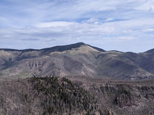
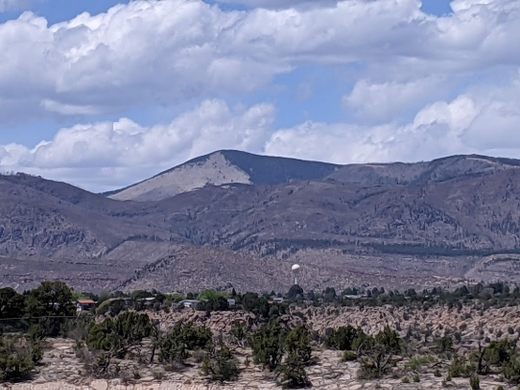
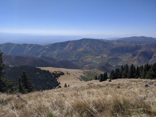
From a distance, the iconic triangular meadow of Chicoma’s southern slope makes it one of the more strikingly beautiful mountains of the Colorado Plateau. Its name comes from the Pueblo word Tschicoma, or “place of much rock.” To the Pueblo people, it is traditionally believed to be the center of the world.

At 11,561 feet high, it is the highest peak of the Jemez Mountains and the second-most topographically prominent peak in New Mexico. It was formerly part of the slope of an enormous supervolcano. When the magma in this volcano was depleted, the entire structure collapsed, leaving a rim of smaller mountains around the Valles Caldera. 

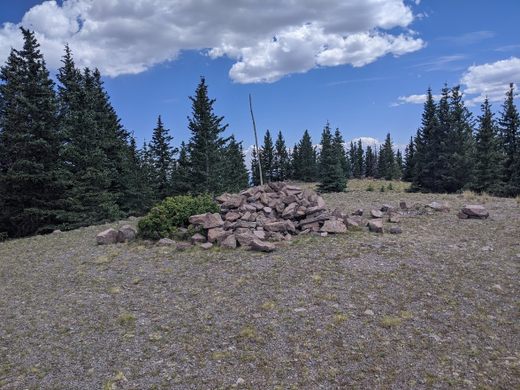
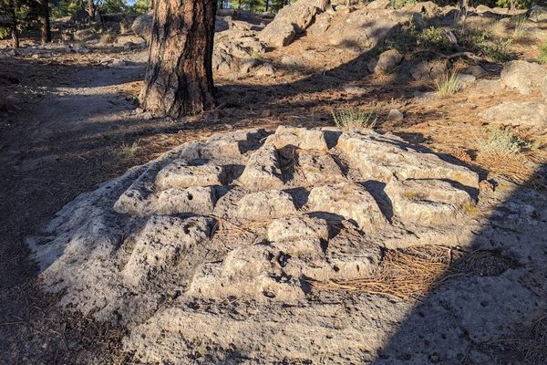
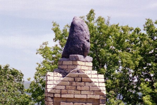
The tree line rises nearly to the summit, so you’ll need to poke around a bit for views of the surrounding mountain ranges, Los Alamos, and Espanola. At the summit itself, you’ll find a large cairn and geological survey marker, as well as a shrine where Pueblo people leave traditional offerings such as corn, obsidian, and feathers. The directional orientation of the seven “rain roads” emanating from the shrine’s center indicates pilgrimages from Taos, San Juan, Santa Clara, San Ildefonso, Jemez, and Cochiti Pueblos, as well as the Navajo.

Places

Discover your next amazing Atlas Place.

Get more unusual and extraordinary places each week with the Atlas Obscura Places newsletter.

Your newsletter subscriptions with us are subject to Atlas Obscura's Privacy Policy and Terms of Use.

Related Tags

Mountains Native Americans Indigenous Geographic Markers Sacred Spaces

Know Before You Go

While much of the southern slopes of the mountain are on Santa Clara pueblo land, the peak of Chicoma is accessible to visitors from the north. This is of course, as long as they've got a good GPS and lack a fear of heights. From Española, take 31 Mile Road and State Highway 565 for about 26 miles. The dirt road is well maintained, and the views are magnificent and/or terrifying, depending on your perspective. There will be a clear parking area about 26 miles in, with a much rougher dirt road extending into the forest. The coordinates for said parking area are 36.020397, -106.398918.

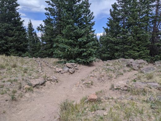
There is no trail that actually leads to the summit. While there are a few old logging roads criss-crossing the upper slopes, most hikers simply accept the bushwhack and march through the forest directly to the summit. Without a GPS, it is easy to get lost here. Black bears and mountain lions are an additional threat here, so make a lot of noise and carry pepper spray. Elk are also commonly found here.

Be mindful of your presence on the mountain, as it is a sacred place to thousands of native people. Do not tamper with the shrine or anything in it, and remember to leave no trace.

Community Contributors

Added By

mikewalker

Published

June 23, 2021

Edit this listing

Make an Edit
Add Photos
Sources
  • https://en.wikipedia.org/wiki/Chicoma_Mountain
  • https://www.fs.fed.us/rm/pubs/rmrs_gtr196/rmrs_gtr196_167_248.pdf
  • https://peakbagger.com/peak.aspx?pid=3989
  • https://www.dangerousroads.org/north-america/usa/7281-chicoma-mountain.html
  • "Guide to the New Mexico Mountains" by Herbert E. Ungnade
Chicoma Mountain
State Hwy 565
Chicoma Mountain, New Mexico, USA
Hernandez, New Mexico, 87537
United States
36.007804, -106.384196
Get Directions

Nearby Places

Mysterious Carved Rocks of Los Alamos

Los Alamos, New Mexico

miles away

Pierotti’s Clowns Monument

Los Alamos, New Mexico

miles away

Fuller Lodge Art Center

Los Alamos, New Mexico

miles away

Explore the Destination Guide

Photo of New Mexico

New Mexico

United States

Places 191
Stories 21

Related Places

  • Abo kiva in foreground, church in background

    Mountainair, New Mexico

    Salinas Pueblo Missions

    The remains of Abó, Gran Quivera, and Qurai are monuments to the long, complicated history of the Indigenous people of the Southwest.

  • Plum Bayou mounds

    Scott, Arkansas

    Toltec Mounds

    People of the Plum Bayou culture built these enormous mounds over 1,000 years ago.

  • Standing Rock Monument

    Fort Yates, North Dakota

    Standing Rock Monument

    This stone, said to have once been a young woman, is sacred to the Dakota and Lakota nations.

  • Inyo County, California

    Coso Rock Art District

    A mountain range on an active U.S. Navy base hides thousands of mysterious prehistoric rock carvings.

  • An aerial view of Serpent Mound in the fall.

    Peebles, Ohio

    The Great Serpent Mound

    The largest earthwork effigy in the world.

  • The distinctive split peak inspired the name.

    Annapurna Circuit, Nepal

    Machhapuchhare (Fishtail Mountain)

    Nepal's unclimbable sacred peak.

  • The “face” of The Turtle as it currently appears.

    Niagara Falls, New York

    The Turtle (Native American Center for the Living Arts)

    One of “America’s Most Endangered Historic Places” is a building shaped like a giant turtle.

  • An example of a buried seed capsule in the Ravenna neighborhood of Seattle.

    Seattle, Washington

    Buried Indigenous Seed Capsules

    Part of Seattle’s Ravenna Creek Drop project, these capsules preserve seeds of plants that predated the city.

Aerial image of Vietnam, displaying the picturesque rice terraces, characterized by their layered, verdant fields.
Atlas Obscura Membership

Become an Atlas Obscura Member


Join our community of curious explorers.

Become a Member

Get Our Email Newsletter

Follow Us

Facebook YouTube TikTok Instagram Pinterest RSS Feed

Get the app

Download the App
Download on the Apple App Store Get it on Google Play
  • All Places
  • Latest Places
  • Most Popular
  • Places to Eat
  • Random
  • Nearby
  • Add a Place
  • Stories
  • Food & Drink
  • Itineraries
  • Lists
  • Video
  • Podcast
  • Newsletters
  • All Trips
  • FAQ
  • Membership
  • Feedback & Ideas
  • Community Guidelines
  • Product Blog
  • Unique Gifts
  • Work With Us
  • About
  • FAQ
  • Advertise With Us
  • Advertising Guidelines
  • Privacy Policy
  • Cookie Policy
  • Terms of Use
Atlas Obscura

© 2026 Atlas Obscura. All Rights Reserved.