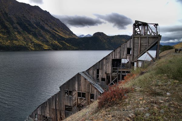
Trips Places Foods Stories Newsletters
Loading...
Loading...
Loading...
Loading...

No search results found for
“”

Make sure words are spelled correctly.

Try searching for a travel destination.

Places near me Random place

Popular Destinations

  • Paris
  • London
  • New York
  • Berlin
  • Rome
  • Los Angeles
Trips Places Foods Stories Newsletters
Sign In Join
Places near me Random place
All the United States California Jamestown Eagle-Shawmut Mine

Eagle-Shawmut Mine

Hidden beneath a lake for decades, this brutalist mine has now emerged from beneath the receding waters.
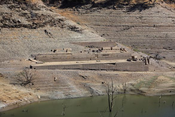
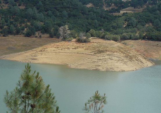
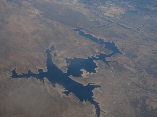
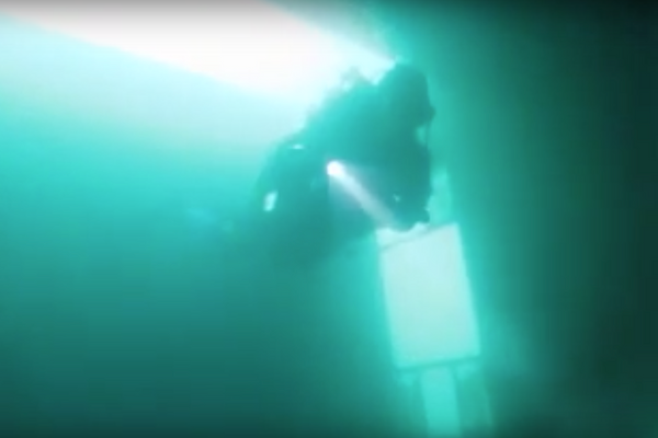
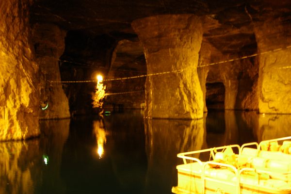
Jamestown, California

Added By
J. Bryce Hidysmith
Email
Been Here
Want to go
Added to list
CAPTION
Eagle-Shawmut Mine   Steve Ryan on Flickr
Eagle-Shawmut Mine   docentjoyce on Flickr
Lake Don Pedro   ken lund on Flickr
Been Here
Want to go
Added to list

About

California's Lake Don Pedro is a jagged reservoir smack dab in the middle of California, and while the desolate wilderness area surrounding it has a number of recreational activities, the true draw to the lake are the remains of the Eagle-Shawmut Mine which have recently reemerged due to the plummeting water level left in the wake of California's drought.

Ground on the mines was first broken in 1850 when deposits of gold, silver, and copper were discovered in the area. Mining the land for nearly 100 years, the mine built a number of structures right into the sloping hillsides. As the mine dug deeper and expanded, it created a number of steep slopes and valleys, each with the severe stratification lines of mine work dug into the surface. However, the output dried up and the mine was closed in 1947 and quickly forgotten to the desert. 

In 1971 the nearby Don Pedro Dam was built, blocking the flow of the Tuolumne River and drowning the nearby gorges and mining areas to create Lake Don Pedro. Had things worked out, the Eagle-Shawmut Mine might have been lost forever beneath the accumulated waters, but thanks to the years-long drought in the state, the waterline of Lake Don Pedro has dramatically receded, revealing the submerged mining installations colloquially referred to as "Brutalist Petra." At the most dramatic site of the exposed mine, the flat earthen building built into the hillside recalls the cyclopean masonry of ancient civilizations despite being only a handful of decades old.  

The old mine can be reached via kayak, but sits on an ungraded slope and is hard to reach by foot, although either way is treacherous. The remains are also only exposed with the fluctuating levels of the lake, so visiting in the dry season would be advised. At the most extreme levels of drought, the mine is further exposed and can be much more easily reached simply by crossing the dry lakebed. The devastating California drought is unquestionably a tragedy and a disaster, but as this mine proves, it can produce no small amount of wonder in its wake.

Related Tags

Mines Underwater Lakes Abandoned Water

Know Before You Go

Two options: 1. Go to the end of Tarantula Mine Road, and climb down the gorge. It'll be pretty hard. (Not recommended in a regular car without 4WD/AWD, it's a steep dirt road). 2. Go to the end of Shawmut Road, on the south shore, and cross in a small boat, or find a fording point further up the reservoir to the west.

Community Contributors

Added By

bryce

Edited By

Martin, Desertrattfink, EricGrundhauser

  • Martin
  • Desertrattfink
  • EricGrundhauser

Published

November 19, 2014

Edit this listing

Make an Edit
Add Photos
Sources
  • http://itouchmap.com/?d=233813&s=CA&f=mine
  • http://westernmininghistory.com/mine_detail/10310611
  • http://www.mercedsunstar.com/sports/outdoors/adam-blauert-column/article3285633.html
  • http://www.news10.net/story/news/local/2014/01/27/shawmut-mine-remnants-revealed-by-dropping-don-pedro-waters/4953535/
  • http://beaut-tree.net/eagle-shawmut-mine/
  • http://www.sonoracentral.com/eagle-shawmut-mine-at-don-pedro-reservoir/
Eagle-Shawmut Mine
Jamestown, California, 95327
United States
37.86826, -120.401028

Nearby Places

Legends Books, Antiques & Soda Fountain

Sonora, California

miles away

Mark Twain's Cabin

Sonora, California

miles away

Knights Ferry Covered Bridge

Knights Ferry, California

miles away

Explore the Destination Guide

Photo of California

California

United States

Places 1,494
Stories 135

Related Stories and Lists

18 Impressive Examples of Brutalist Architecture

List

By Roxanne Hoorn

Related Places

  • View of the exposed bridge looking north, 2008.

    Tallassee, Tennessee

    Abrams Creek Underwater Bridge

    Abandoned for 60 years, this submerged bridge was completely forgotten until the lake was drained.

  • View of the Venus Mine looking to the south.

    Tagish, Yukon

    Venus Silver Mine

    The picturesque remains of an abandoned silver mine slope down to Tagish Lake in the Yukon.

  • Improvement District No. 9, Alberta

    Lake Minnewanka Underwater Ghost Town

    The only way to visit this old resort hotel is with scuba gear.

  • Billion Gallon Lake

    Bonne Terre, Missouri

    Bonne Terre Mine

    The world's largest man-made underground caverns offer unparalleled underwater wonders.

  • Ashton’s Flash

    Wincham, England

    Ashton's and Neumann's Flashes

    Formed by the collapse of salt mines and later used for dumping industrial waste, these lakes are now part an unusual, biodiverse parkland.

  • Seesicht

    Zug, Switzerland

    'Seesicht' ('Lake View')

    Walk down these stairs to get an underwater view of Switzerland's Lake Zug.

  • Opalsøen (The Opal Lake)

    Allinge, Denmark

    Opalsøen (The Opal Lake)

    Once a granite mine, this beautiful lake is the perfect place to cliff jump and zipline in Denmark

  • A Celles ruin.

    Celles, France

    Celles

    Half a century after it was abandoned, this ghost town is coming back to life.

Aerial image of Vietnam, displaying the picturesque rice terraces, characterized by their layered, verdant fields.
Atlas Obscura Membership

Become an Atlas Obscura Member


Join our community of curious explorers.

Become a Member

Get Our Email Newsletter

Follow Us

Facebook YouTube TikTok Instagram Pinterest RSS Feed

Get the app

Download the App
Download on the Apple App Store Get it on Google Play
  • All Places
  • Latest Places
  • Most Popular
  • Places to Eat
  • Random
  • Nearby
  • Add a Place
  • Stories
  • Food & Drink
  • Itineraries
  • Lists
  • Video
  • Podcast
  • Newsletters
  • All Trips
  • Family Trip
  • Food & Drink
  • History & Culture
  • Wildlife & Nature
  • FAQ
  • Membership
  • Feedback & Ideas
  • Community Guidelines
  • Product Blog
  • Unique Gifts
  • Work With Us
  • About
  • FAQ
  • Advertise With Us
  • Advertising Guidelines
  • Privacy Policy
  • Cookie Policy
  • Terms of Use
Atlas Obscura

© 2025 Atlas Obscura. All Rights Reserved.