About
Copper, of course, has been known since antiquity, but it only became an important industrial metal in the latter 19th century with the rise of large-scale electrical technology. Previously copper deposits were worked only if cheap and accessible.
When the Grand Gulch deposit, then called Adam's Lode and marked by brilliant blue and green copper-bearing pebbles on the ground surface, was discovered after the Civil War, the shifting economics of copper led to mining beginning in 1872. Some of the ore concentrates assayed up to 75-80% copper, an extraordinary amount. The concentrates were freighted by wagon to the railroad line at St. Thomas, Nevada, whence they were shipped to smelters in Salt Lake City, Utah.
Even with increased demand for copper the operation remained marginal due to the transportation difficulties. Peak production, and profitability, only occurred during World War I. At this point some 80 people are thought to have lived by the mine, including the women and children in the miners' families. However, copper prices plummeted after the war due to the precipitous drop in demand, and the mine shut down in 1919. Coincidentally, the ore grade also dropped off at this point.
The mine underwent something of a revival in the early 1950s, when new technology—sulfuric acid leaching of the low-grade leftovers that were still heaped around the mine site—led to renewed production. Overall, some 6.6 million pounds of copper and 24,000 oz of silver were recovered from the deposit.
The deposit was hosted in a so-called "breccia pipe." Breccia (pronounced "BRETCH-uh", Italian for "broken") refers to a rock made of broken pieces of other rock. The breccia pipe formed when overlying rocks collapsed into limestone caves in the Redwall Limestone, hundreds of feet below the surface. The collapse then propagated up through the overlying strata. Such a column of broken rock can provide a conduit for metal-bearing solutions from deep in the crust, and these solutions in turn can precipitate metal deposits. There are around 1300 breccia pipes known in the vicinity, but only a few host metal deposits. Some breccia pipes host uranium mineralization, a fact of especial interest during the uranium boom of the early 1950s, but there proved to be no economic uranium mineralization at Grand Gulch. A couple of large abandoned dump trucks at the site date from this era.
Know Before You Go
Grand Gulch Mine remains extremely remote today, probably even more so than it was in the early 20th century, because there are now no permanent settlements in the area other than a handful of ranches. Reaching the site requires at least three hours on dirt roads (more in case of washouts) from St. George, Utah. High clearance will be required, and even 4wd may be required if the roads are washed out. Be sure to top off with fuel beforehand and have a spare tire; there are no services beyond St. George. Bring plenty of water, too, especially in the warm months.
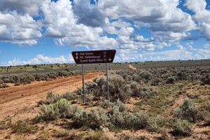
The most direct route is as follows. From Interstate 15 take the Southern Parkway (Utah SR-7) east from Exit 2 and turn south at Exit 3, which will be signed as River Road. You will quickly arrive at the Arizona state line, where the road becomes BLM (Bureau of Land Management) 1069. In 20.6 miles you will reach the junction with BLM 1004 in Wolf Hole Valley (at about 36.74767 N, 113.54655 W). Continue straight; the road has now become Mohave County Road 5. Stay on CR5 for 18.5 miles to the junction with CR103 on the right (west), which will be signed for Mt. Dellenbaugh and is at about 36.54478 N, 113.38794 W. Turn right here and proceed 25.2 miles to the junction with BLM 1002 on the right (at about 36.31201 N, 113.61178 W), which will be signed for Grand Gulch Mine. Turn right here. The road drops through scenic Pigeon Canyon which is subject to frequent washouts; 4wd may be necessary. In 10.3 miles you reach the intersection with BLM 1012 on the left (at 36.30217 N, 113.73972 W). Here there are some large cattle watering troughs. Bear right to stay on BLM 1002; it is now about 4 miles to the Grand Gulch Mine. Be careful parking by the mine site because of buried metal pieces which could puncture tires.
The BLM has reopened the old road (now BLM 1050) that led west from the mine down through Grand Gulch Canyon, where ore was carried out by wagons and later by trucks. However, this route is now a difficult 4wd trail passable only to extreme 4wd vehicles. It is not passable to stock SUVs and pickups even if they have 4wd.
The area lies completely within Grand Canyon-Parashant National Monument, and all natural and historical features are protected. Please don't collect artifacts or mineral specimens; leave them for the next visitor.
Community Contributors

Added By
Published
August 7, 2026