Places Foods Stories Newsletters
Top Destinations
Latest Places
Most Popular Places Random Place Lists Itineraries
Add a Place
Download the App
Top Destinations
View All Destinations »
Countries
  • Australia
  • Canada
  • China
  • France
  • Germany
  • India
  • Italy
  • Japan
Cities
  • Amsterdam
  • Barcelona
  • Beijing
  • Berlin
  • Boston
  • Budapest
  • Chicago
  • London
  • Los Angeles
  • Mexico City
  • Montreal
  • Moscow
  • New Orleans
  • New York City
  • Paris
  • Philadelphia
  • Rome
  • San Francisco
  • Seattle
  • Stockholm
  • Tokyo
  • Toronto
  • Vienna
  • Washington, D.C.
Latest Places
View All Places »
Elk carvings with red paint
Alta Rock Carvings
Shrine of the Most Blessed Sacrement
Finnish presidents
Visulahti Wax Museum
City Island Nautical Museum in the former P.S. 17.
City Island Nautical Museum
Latest Places to Eat & Drink
View All Places to Eat »
Pensão Amor
The Bundesbüdchen sits outside Bonn's UN Campus and many of the Bonn Republic's converted government buildings.
Bundesbüdchen
Food window and entrance of center.
Indian Arts Center
Steaming Tender Restaurant
Tiptree Jam Museum entrance.
Tiptree Jam Museum
Loading...

No search results found for
“”

Make sure words are spelled correctly.

Try searching for a travel destination.

Places near me Random place

Popular Destinations

  • Paris
  • London
  • New York
  • Berlin
  • Rome
  • Los Angeles
Places Foods Stories Newsletters
Sign In Join
Places near me Random place
All Tajikistan Longest Road Through No Man’s Land

Longest Road Through No Man’s Land

The Pamir Highway between Tajikistan and Kyrgyzstan takes a mere hour driving through a stretch of No Man’s Land.

Tajikistan

Aksel profile photo
Added By
Aksel
Email
Been Here
Want to go
Added to list
CAPTION
The crossing in summertime   Ivana Kelfka Fleková
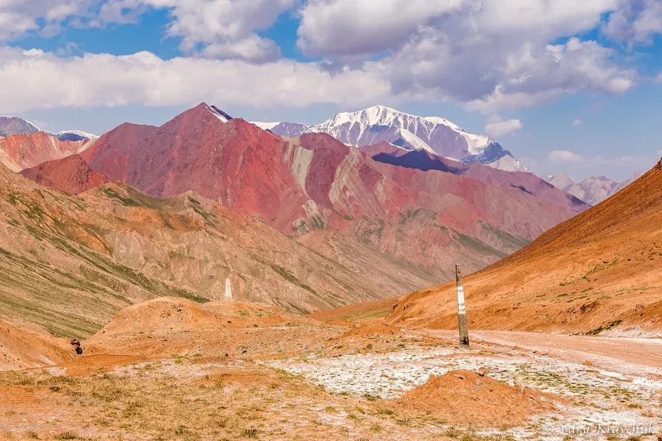
Red mountains in No Man’s Land   Yury Kravchuk
Unmaintained roads   Aksel / Atlas Obscura User
22 long kilometers …   Aksel / Atlas Obscura User
Border crossing in No Man’s Land   Aksel / Atlas Obscura User
Been Here
Want to go
Added to list

About

The Pamir Highway is only open some months per year, with passes at 4,280 and 4,655 meters above sea level. The highway is so remote and oxygen-deprived that the actual border crossing lacks checkpoints. Between Tajikistan and Kyrgyzstan stretches a long 22 kilometers of non-maintained road through No Man’s Land.

The Secret Road

The Pamir Highway was planned in 1891 by Lieutenant Colonel Bronislav Grombchevsky, who convinced a Russian Tsar that a road was the only way to win the "Great Game" against the British in Afghanistan-Pakistan-India. In 1912, engineers were dispatched to upgrade a medieval horse-trail through the Himalayas to a full-blown road. But the Pamirs do not surrender easily. Local legend whispers that the mountains exacted a terrible price: not a single engineer or builder returned dead or alive. It wasn't until 1933 that the Soviets constructed "The Secret Road", a military lifeline intended as an escape route from the USSR's into the Orient. The OGPU (KGB) led the construction of the Pamir Highway with slave labour from political opponents. The exact human toll of the road works is unknown. But for comparison, the Karakoram highway through the Himalayas is known to have costed more than 800 lives. The Pamir Highway was only opened in the 1980’s. The pledge to the Tsar was then full-filled, after almost a century, when Russia invaded Afghanistan in 1979. The total death toll of the Pamir Highway to Afghanistan remains a public secret.

Kyzyl-Art Pass at 4,280 meters

Since the independence of Tajikistan and Kyrgyzstan, the Kyzyl-Art Pass is one of the highest border-crossing in the world at 4,280 meters altitude. The distance between the two border check-points of Bordöbö and Kyzyl-Art is 22 kilometers. That might seem trivial on a map, but it is an eternity in the Pamirs. The asphalt is from the 1970’s, and as much remains of it as from the USSR. Most of the road has eroded by trucks and landslides. The road has no guardrails. Whilst both left-hand and right-hand vehicles drive here, you can directly recognize the one rigidly having their eyes locked at the road, avoiding potholes, too scared to look into the deep abysses, gasping for oxygen, their brains ruminating on life-questions whether oncoming traffic should be called opponents. The road through No Man’s Land takes an eternity.

The People of the Sun

Long before the crescent of Islam reached the valleys, the Pamiris were the "People of the Sun," adherents of an ancient Zoroastrian fire-worship that still pulses in the veins of their culture. Even today, traditional Pamiri homes (chid) are built as living solar calendars; their skylights consist of four concentric squares representing earth, water, air, and fire, filtering the alpine light into a sacred geometry that has survived for over three millenniums. Old graveyards can still be seen; shrines adorned with horns stand as silent guards against evil spirits.

At the actual border stands a surreal monument to this Tajik pride: a statue of the Marco Polo Sheep (locally called “Argali” or scientific name “Ovis ammon polii”), often mistaken for a mountain goat or ibex. With its massive, spiraling horns, this iron beast gazes out over the desolate No Man’s Land, where nations cease to exist.

Places

Discover your next amazing Atlas Place.

Get more unusual and extraordinary places each week with the Atlas Obscura Places newsletter.

Your newsletter subscriptions with us are subject to Atlas Obscura's Privacy Policy and Terms of Use.

Know Before You Go

Disclaimer: Obviously our planet has other tracks through no-man’s land, but this one is breath-taking for the longest time, also literally, compared to the 25 km No-Man’s Land between Mongolia and Russia’s Altai republic (can be driven in half an hour), or compared to a track on Antartica (a series of flags in the snow, not a real rod).The road is the destination

Driving the Pamir Highway is an adventure on its own. It can only be driven by 4x4, unless you’re a local lorry-driver (…). The route goes from Osh in Kyrguzstan to Dushanbe in Tajikistan. No public transport is available, but you can ask your accommodation to arrange a private driver or shared taxi. Visa must be obtained up-front and a special “GBAO” permit is required as you’re traversing an area with potentially political uprises. Do not travel alone.

The altitude climb is quite fast, especially Northbound. To prevent (severe) altitude sickness, it is strongly recommended to stay overnight in a mountain village at at least 3,000 meters altitude e.g. accommodate your body to low-oxygen levels prior the final climb. There are no medical posts in No Man’s Land, no cell-phone coverage, it’s just nothing.Pamir winters are long and harsh, temperature can drop to -40 Celsius. Roads vanish under a thick layer of snow and frozen mud. Typically, the pass is open from June to September, depending on wheather. Be aware, sometimes snow is reported already in August. Outside of these months the No Man’s Land belongs to snow leopards and Yeti.

Community Contributors

Aksel profile photo

Added By

Aksel

K KyivanMoose profile photo cjklever profile photo

Edited By

KyivanMoose, cjklever

  • K KyivanMoose profile photo KyivanMoose
  • cjklever profile photo cjklever

Published

May 6, 2026

Edit this listing

Make an Edit
Add Photos
Sources
  • https://againstthecompass.com/en/kyzyl-art-pass-kyrgyzstan-tajikistan-border/
  • https://en.wikipedia.org/wiki/M41_highway
  • https://www.advantour.com/tajikistan/pamir-highway/history.htm
  • https://lisagermany.com/kyrgyzstan-tajikistan-via-pamir-highway-part-2/
  • https://eurasianet.org/tajikistans-pamir-highway-a-decaying-lifeline-to-the-east
  • https://caravanistan.com/tajikistan/pamir-highway/#road
  • https://againstthecompass.com/en/kyzyl-art-pass-kyrgyzstan-tajikistan-border/

Related Tags

Roads Border Crossings
Longest Road Through No Man’s Land
Tajikistan
39.394287, 73.304379
Visit Website

Nearby Places

Muzey Sulayman Too

Osh, Kyrgyzstan

miles away

Sarez Lake

Rushon, Tajikistan

miles away

Explore the Destination Guide

Photo of Tajikistan

Tajikistan

Asia

Places 15

Nearby Places

Muzey Sulayman Too

Osh, Kyrgyzstan

miles away

Sarez Lake

Rushon, Tajikistan

miles away

Explore the Destination Guide

Photo of Tajikistan

Tajikistan

Asia

Places 15

Related Places

  • Sani Pass

    Mkhomazi Wilderness area, South Africa

    Sani Pass

    Brace yourself for the slowest, scariest, most spectacular drive, down the Drakensberg Escarpment.

  • The Poker Creek border crossing.

    Eagle, Alaska

    Poker Creek

    The northernmost international land border crossing in the United States.

  • Puente de la Amistad

    Ciudad del Este, Paraguay

    Puente de la Amistad

    An international border crossing near the famous Iguazú Falls where bargain hunters and curious tourists stream between Brazil and Paraguay.

  • New mural on street

    Bellefontaine, Ohio

    Shortest Street in America

    Blink and you’ll miss it—the tiniest street in America packs a lot of charm into just a few steps.

  • Hill Road Taxi

    Hong Kong

    Hill Road Flyover

    This striking high elevated road snakes downhill between densely packed buildings.

  • Freedmen’s Town Bricks

    Houston, Texas

    Freedmen’s Town Bricks

    After emancipation, former slaves paved the roads of their newly built settlement with these bricks.

  • The Hugglescote Deathstar roundabout

    Hugglescote, England

    The Hugglescote Death Star

    An obscure roundabout modeled on the Death Star from “Star Wars.”

  • Taipei Bridge Scooter Waterfall

    Taiwan

    Taipei Bridge Scooter Waterfall

    The cascade created by Taipei’s rush-hour traffic has become one of the city’s quirkiest photo spots.

Aerial image of Vietnam, displaying the picturesque rice terraces, characterized by their layered, verdant fields.
Atlas Obscura Membership

Become an Atlas Obscura Member


Join our community of curious explorers.

Become a Member

Get Our Email Newsletter

Follow Us

Facebook YouTube TikTok Instagram Pinterest RSS Feed

Get the app

Download the App
Download on the Apple App Store Get it on Google Play
  • All Places
  • Latest Places
  • Most Popular
  • Places to Eat
  • Random
  • Nearby
  • Add a Place
  • Stories
  • Food & Drink
  • Itineraries
  • Lists
  • Video
  • Podcast
  • Newsletters
  • All Trips
  • Membership
  • Feedback & Ideas
  • Community Guidelines
  • Product Blog
  • Unique Gifts
  • Work With Us
  • About
  • FAQ
  • Advertise With Us
  • Advertising Guidelines
  • Privacy Policy
  • Cookie Policy
  • Terms of Use
Atlas Obscura

© 2026 Atlas Obscura. All Rights Reserved.

Keep Reading

Create a free Atlas Obscura account to unlock the rest of this story and explore more extraordinary places.
Create a Free Account or Log In