Places Foods Stories Newsletters
Loading...
Loading...
Loading...

No search results found for
“”

Make sure words are spelled correctly.

Try searching for a travel destination.

Places near me Random place

Popular Destinations

  • Paris
  • London
  • New York
  • Berlin
  • Rome
  • Los Angeles
Places Foods Stories Newsletters
Sign In Join
Places near me Random place
All the United States Utah Emery County MK Tunnels

MK Tunnels

Traces remain from early Cold War experiments on the vulnerability of underground installations to surface explosions

Emery County, Utah

slgwv profile photo
Added By
slgwv
Email
Been Here
Want to go
Added to list
CAPTION
Interpretive sign on Buckhorn Draw road.   slgwv / Atlas Obscura User
Grate blocking access to the tunnel off Buckhorn Draw.   slgwv / Atlas Obscura User
View, through the grate, down the tunnel off Buckhorn Draw.   slgwv / Atlas Obscura User
The adit (tunnel) off Buckhorn Draw.   slgwv / Atlas Obscura User
Trail to the tunnel off Buckhorn Draw (visible behind).   slgwv / Atlas Obscura User
Chain-link fence around one of the open shafts.   slgwv / Atlas Obscura User
Storage bunker left over from construction of the tunnels. This is near the campground in Buckhorn Draw.   slgwv / Atlas Obscura User
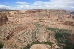
Canyon immediately to the west of the main test area. An adit (not visible) from the east (left) side of this canyon intersects the main shaft.   slgwv / Atlas Obscura User
Overlooking the main test area from near the sign, view more to the left.   slgwv / Atlas Obscura User
Overlooking the main test area from near the sign.   slgwv / Atlas Obscura User
Interpretive sign overlooking the main test area.   slgwv / Atlas Obscura User
Fenced-off crater over breached concrete slab covering shaft. Large explosion crater in the background.   slgwv / Atlas Obscura User
View southwest across a fenced-off shaft to the big explosion crater.   slgwv / Atlas Obscura User
Fenced-off explosion crater.   slgwv / Atlas Obscura User
Looking into the large crater made by one of the biggest surface explosions.   slgwv / Atlas Obscura User
Looking through the chain-link fence to the edge of the main shaft.   slgwv / Atlas Obscura User
Gap in the concrete cap over the main shaft, blown open by a subsequent surface explosion.   slgwv / Atlas Obscura User
Looking through the chain-link fence at the rubble now covering the site of the main shaft.   slgwv / Atlas Obscura User
Looking southeasterly over the main experimental site. The chain-link fence around the main shaft can be made out just up and to the right of center. The edge of the large crater made by one of the biggest surface blasts is visible behind.   slgwv / Atlas Obscura User
Been Here
Want to go
Added to list

About

By 1950 what was to become known as the Cold War was settling into place. The Soviet Union had detonated a nuclear device in the late 1940s, so the US nuclear monopoly was broken. In addition, both sides would successfully test thermonuclear weapons (a.k.a. hydrogen bombs) in the early 1950s.

So the sheer destructive power of nuclear weapons, even before operational thermonuclear devices, motivated the search for ways to "harden" (in current jargon) command and control centers to survive nuclear attack. Putting them underground was an obvious approach, but how deep and in what kind of rock?

The experiments here helped address these issues. Horizontal tunnels were dug in the Navajo Sandstone, a thick massive sandstone with relatively uniform mechanical properties. Explosions of various sizes were then detonated above these tunnels, while then-state-of-the-art instrumentation was installed in the tunnels to measure the effects. The investigations were carried out by Morrison-Knudsen (hence "MK tunnels"), at the time a well-known contractor.

Although the experiments were secret, and indeed remained classified till the 1980s, Morrison-Knudsen was remarkably open about the work. Test explosions would be announced and some were even photographed by people living around the area.

Testing wound down in 1952 and, presumably based on the test results, the Navajo Sandstone was deemed unsuitable for underground installations. Results from testing elsewhere presumably led to the construction of the underground installations in Cheyenne Mountain instead.

Places

Discover your next amazing Atlas Place.

Get more unusual and extraordinary places each week with the Atlas Obscura Places newsletter.

Your newsletter subscriptions with us are subject to Atlas Obscura's Privacy Policy and Terms of Use.

Know Before You Go

One of the tunnels is easily accessible from the Buckhorn Wash (or Draw) road, at 39.16418 N, 110.73599 W. As with the other tunnels, it is blocked off but with an open grate to give bats access.  (Abandoned tunnels like this have become important habitats for bats.)  An old shed-like structure, said to have been used for storing explosives, is not far away, across the road around 39.16778 N, 110.73785 W. There were also other structures around here during the construction, but nothing else is left.

The main tunneling site, however, is to the east on the bench above Buckhorn Draw, about 1.25 miles away. To get there, go up the Buckhorn Draw road to its junction with Green River Cutoff Road, at about 39.17081 N, 110.75135 W, and turn right. Go 3.5 miles to a junction at 36.16972 N, 110.70405 W and turn right onto BLM road 3432. Go 0.9 mile and bear right onto MK Tunnels Road at a junction around 39.16134 N, 110.71341 W. Continue about another 0.3 mile to where the edge of the bench drops off on the left. This overlooks the area where many of the explosions were set off, leaving obvious craters, some of which are fenced off. Use extreme caution in this area, especially with children and pets, because some of the craters have broken into the tunnels below. The area is also steep and covered with loose rock. Several interpretive signs describe the site. The portal to the main tunnel is at the base of the bluff to the west, about 39.15826 N, 110.71844 W. A steep trail leads down to this point.

The Green River Cutoff Road is graded and should be passable to passenger cars, at least in dry weather. Going down to the MK roads, however, will require high clearance. It's a straightforward hike, however, if an adequate vehicle is not available.

Community Contributors

slgwv profile photo

Added By

slgwv

Published

July 17, 2026

Edit this listing

Make an Edit
Add Photos
MK Tunnels
Mk Tunnels
Emery County, Utah
United States
39.160016, -110.716154
Get Directions

Nearby Places

Buckhorn Wash Pictograph Panel

Green River, Utah

miles away

Wedge Overlook

Castle Dale, Utah

miles away

Prehistoric Museum

Price, Utah

miles away

Explore the Destination Guide

Photo of Utah

Utah

United States

Places 170
Stories 29

Nearby Places

Buckhorn Wash Pictograph Panel

Green River, Utah

miles away

Wedge Overlook

Castle Dale, Utah

miles away

Prehistoric Museum

Price, Utah

miles away

Explore the Destination Guide

Photo of Utah

Utah

United States

Places 170
Stories 29
Aerial image of Vietnam, displaying the picturesque rice terraces, characterized by their layered, verdant fields.
Atlas Obscura Membership

Become an Atlas Obscura Member


Join our community of curious explorers.

Become a Member

Get Our Email Newsletter

Follow Us

Facebook YouTube TikTok Instagram Pinterest RSS Feed

Get the app

Download the App
Download on the Apple App Store Get it on Google Play
  • All Places
  • Latest Places
  • Most Popular
  • Places to Eat
  • Random
  • Nearby
  • Add a Place
  • Stories
  • Food & Drink
  • Itineraries
  • Lists
  • Video
  • Podcast
  • Newsletters
  • All Trips
  • Membership
  • Feedback & Ideas
  • Community Guidelines
  • Product Blog
  • Unique Gifts
  • Work With Us
  • About
  • FAQ
  • Advertise With Us
  • Advertising Guidelines
  • Privacy Policy
  • Cookie Policy
  • Terms of Use
Atlas Obscura

© 2026 Atlas Obscura. All Rights Reserved.