Trips Places Foods Stories Newsletters
Loading...
Loading...
Loading...
Loading...

No search results found for
“”

Make sure words are spelled correctly.

Try searching for a travel destination.

Places near me Random place

Popular Destinations

  • Paris
  • London
  • New York
  • Berlin
  • Rome
  • Los Angeles
Trips Places Foods Stories Newsletters
Sign In Join
Places near me Random place
All the United States New York State Manhattan Vintage Massimo Vignelli Subway Map
Vintage Massimo Vignelli Subway Map is permanently closed.

This entry remains in the Atlas as a record of its history, but it is no longer accessible to visitors.

Vintage Massimo Vignelli Subway Map

There's a piece of New York City transportation history hidden in plain sight at a Manhattan subway stop.

New York, New York

Added By
Ashawnta Jackson
Email
Been Here
Want to go
Added to list
CAPTION
Massimo Vignelli’s much-debated 1972 subway map.   oinonio/CC BY-SA 2.0
Vignelli map, detail.   oinonio/CC BY-SA 2.0
6th Avenue/57th Street station.   Harrison Leong/CC BY-SA 4.0
Been Here
Want to go
Added to list

About

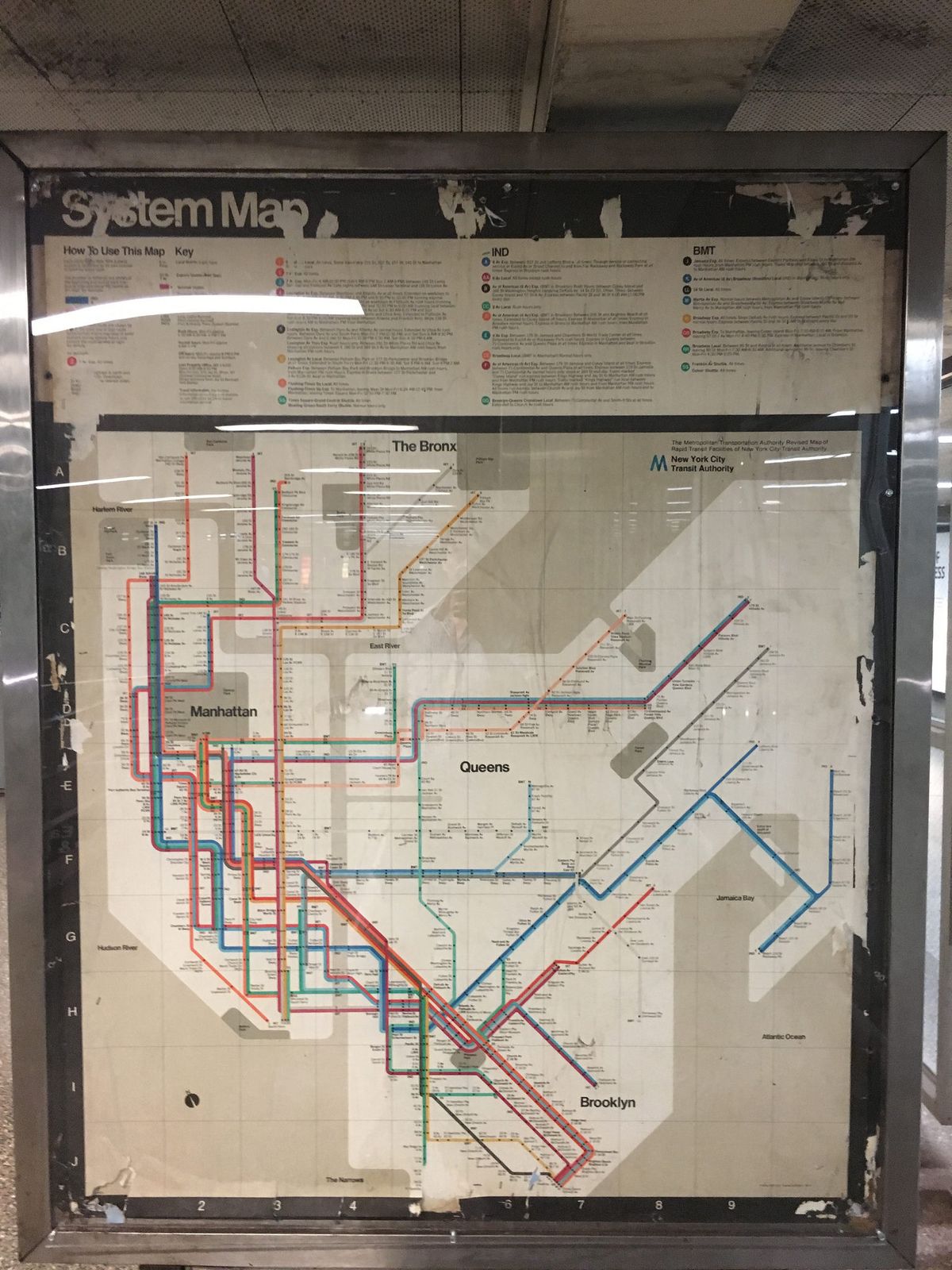
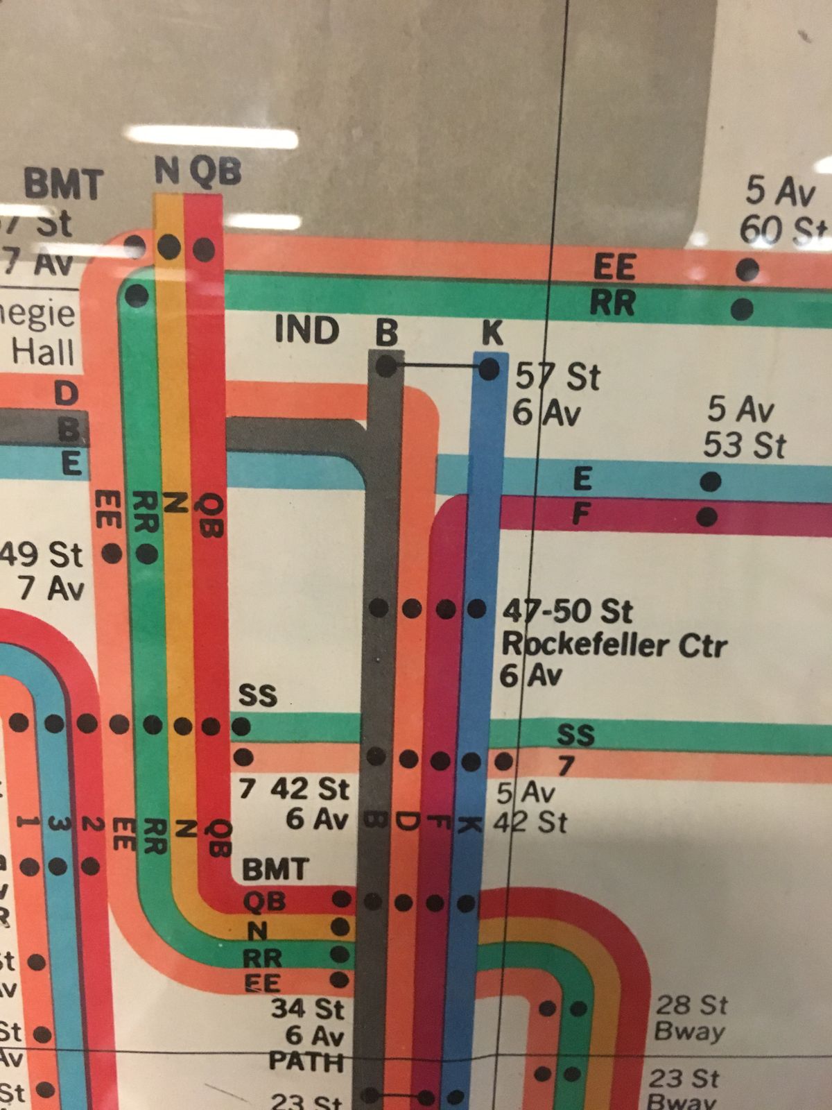
When designer Massimo Vignelli's redesigned New York City subway map appeared in 1972, people were less than enthusiastic. Where previous versions relied on a more recognizable approach to the map—water was blue, Central Park was more or less shaped like the actual location—Vignelli took a more unconventional approach. Water was beige and Central Park was square and scaled-down.

Vignelli's map, or as he preferred, "diagram," wasn't intended to be an accurate representation of New York City. “There is no reason why this geography has to be literal," Vignelli explained. "It could be completely abstract.”

He therefore decided to reinterpret the subway routes with some creative cartographic design. Stations became dots, threaded to their neighbors by color-coded lines with sharp angles. It was orderly, but not necessarily well-received by anyone but design lovers.

City residents disliked the artistic misrepresentations of their city. Tourists found it difficult to match their destinations with the representations on the map. In an era before Google Maps, his artistic flair made navigating the city's underbelly a touch more stressful.

In 1979, the city replaced Vignelli's map with a more traditional geographical model. This left Vignelli's as a much-maligned, but also a much-revered treasure for graphic design enthusiasts.

In later years, however, even the city embraced Vignelli's creation, hiring the designer to create a map for the New York City Metropolitan Transportation Authority's mobile app using his original design as inspiration.

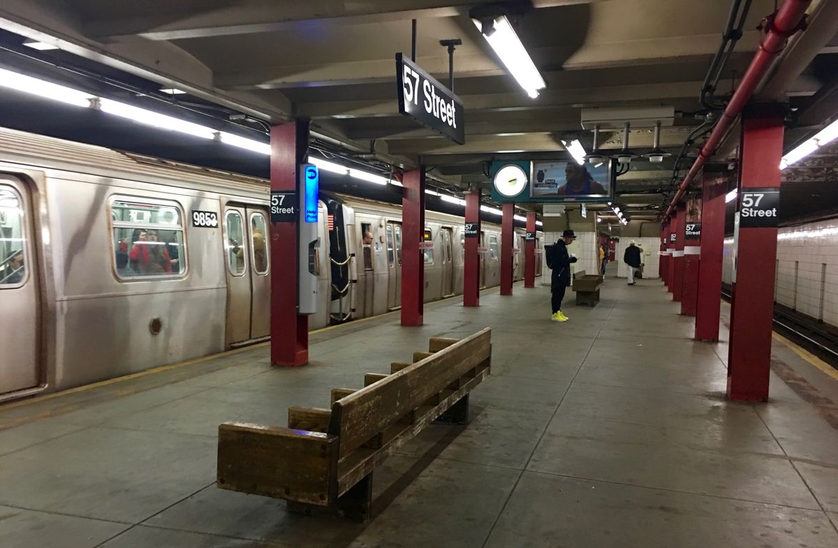
Most of the original Vignelli posters were torn down or covered over, but a recent discovery at a subway station on 57th Street has revealed the poster once again. The Manhattan station, a stop on the F-line, has one of Vignelli's posters on display. Yet though there was some recent hype around this discovery, it's more accurately a re-discovery, as the poster was spotted as long ago as 1999.

This new excitement is probably a combination of new eyes seeing the poster in its native habitat for the first time and amazement at the fact it's still there (although the poster's home underneath plexiglass may explain the latter). But for as long as it remains, tourists and residents alike can catch a glimpse of this controversial map, complete with its beige water and square park.


Related Tags

Art Design Transportation Cities Maps Subways Underground

Community Contributors

Added By

Ashawnta

Edited By

Thewanderingmeatball, Dellin Betansaze

  • Thewanderingmeatball
  • Dellin Betansaze

Published

November 14, 2017

Edit this listing

Make an Edit
Add Photos
Sources
  • http://www.openculture.com/2014/05/designer-massimo-vignelli-explains-his-iconic-1972-new-york-city-subway-map.html
  • http://www.nytimes.com/2012/08/06/arts/design/the-subway-map-that-rattled-new-yorkers.html
  • http://www.metropolismag.com/cities/transportation/a-new-subway-map-for-new-york-city/
Vintage Massimo Vignelli Subway Map
57th Street F-Train Stop
New York, New York
United States
40.763786, -73.977155
Get Directions

Nearby Places

Burger Joint

New York, New York

miles away

6 1/2 Avenue: Manhattan's Secret Street

New York, New York

miles away

Water Tower

New York, New York

miles away

Explore the Destination Guide

Photo of New York

New York

New York

Places 407
Stories 90

Nearby Places

Burger Joint

New York, New York

miles away

6 1/2 Avenue: Manhattan's Secret Street

New York, New York

miles away

Water Tower

New York, New York

miles away

Explore the Destination Guide

Photo of New York

New York

New York

Places 407
Stories 90

Related Places

  • Osokorky Metro Station.

    Kyiv, Ukraine

    Osokorky Metro Station

    This underground transport hub doubles as an art gallery.

  • Toledo Art Station of the Naples Metro.

    Naples, Italy

    Toledo Art Station

    This shining multicolored metro station deep under Naples is said to be the most beautiful in Europe.

  • Covent Garden labyrinth.

    London, England

    London Underground Labyrinths

    A labyrinth hides in plain sight at each of the city's 270 Tube stations.

  • Kungsträdgården metro station.

    Stockholm, Sweden

    Kungsträdgården Metro Station

    Stockholm's deepest subway station is also a stunning ecological wonder.

  • Komsomolskaya station.

    Moscow, Russia

    Moscow Metro Stations

    The gorgeous entrances into the city's underbelly look more like grand halls than subway stops.

  • A look inside the Depot.

    London, England

    London Transport Museum Depot

    The majority of the museum's large collection is held in a storage space open to the public a few times a year.

  • Art Nouveau Vestibule

    Prague, Czechia

    Prague Hlavni Nadrazi Vestibule

    A historic and beautiful Art Nouveau chamber in a historic railway station.

  • Alisher Navoiy Station.

    Tashkent, Uzbekistan

    Tashkent Metro Stations

    An underground world of gorgeous, palatial metro stations designed as a nuclear shelter complex.

Aerial image of Vietnam, displaying the picturesque rice terraces, characterized by their layered, verdant fields.
Atlas Obscura Membership

Become an Atlas Obscura Member


Join our community of curious explorers.

Become a Member

Get Our Email Newsletter

Follow Us

Facebook YouTube TikTok Instagram Pinterest RSS Feed

Get the app

Download the App
Download on the Apple App Store Get it on Google Play
  • All Places
  • Latest Places
  • Most Popular
  • Places to Eat
  • Random
  • Nearby
  • Add a Place
  • Stories
  • Food & Drink
  • Itineraries
  • Lists
  • Video
  • Podcast
  • Newsletters
  • All Trips
  • Wildlife & Nature
  • FAQ
  • Membership
  • Feedback & Ideas
  • Community Guidelines
  • Product Blog
  • Unique Gifts
  • Work With Us
  • About
  • FAQ
  • Advertise With Us
  • Advertising Guidelines
  • Privacy Policy
  • Cookie Policy
  • Terms of Use
Atlas Obscura

© 2025 Atlas Obscura. All Rights Reserved.