Places Foods Stories Newsletters
Loading...
Loading...
Loading...

No search results found for
“”

Make sure words are spelled correctly.

Try searching for a travel destination.

Places near me Random place

Popular Destinations

  • Paris
  • London
  • New York
  • Berlin
  • Rome
  • Los Angeles
Places Foods Stories Newsletters
Sign In Join
Places near me Random place
All the United States Vermont Underhill Wampahoofus Trail
AO Edited

Wampahoofus Trail

This path is named for a mythical half-boar, half-deer creature that once roamed the Green Mountains.

Underhill, Vermont

D dylanvt profile photo
Added By
dylanvt
Email
Been Here
Want to go
Added to list
CAPTION
Sign announcing Wampahoofus Trail, with the Forehead in the distance   Famartin
An illustration of a wampahoofus.   Walter Bender
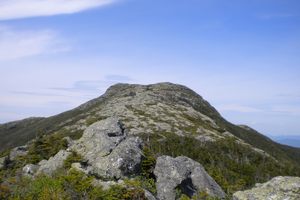
View to the southwest from near the top of the Forehead.   dylanvt / Atlas Obscura User
A pup enjoying the funny name.   dylanvt / Atlas Obscura User
Under a rock on the Rock Garden Trail, just off Wampahoofus.   dylanvt / Atlas Obscura User
Near the top on Wampahoofus Trail.   dylanvt / Atlas Obscura User
Been Here
Want to go
Added to list

About

Wampahoofus Trail starts from Butler Lodge around 3,000 feet up the side of Mount Mansfield, Vermont's highest peak, and continues until it meets the legendary Long Trail atop Mansfield's generally comparatively unpeopled Forehead area. To get to Wampahoofus, you'll first have to hike up the 1.8 mile Butler Lodge Trail. You can stay overnight in the lodge or continue directly to Wampahoofus.

The trail was named for a mythical creature of Vermont's Green Mountains that predates even the yeti and Bigfoot in the Western consciousness. Also known as a gyascutus or a sidehill gouger, the wampahoofus was known for its uneven legs (a pair on one side was always longer than the other) that allowed it to move in only one direction around the mountain. If a clockwise wampahoofus met a counterclockwise peer on a ridge, they would fight to the death so one could pass. They could mate only when their circular routes intersected. Eventually, their shorter legs became so short that they couldn't move or mate, and they soon died out. The trail was purportedly named by a Professor Ray Buchanan, who noted a rock formation that looked like the profile of the wampahoofus.

A short way along the trail you can take a detour down the short but aptly named Rock Garden Trail, which connects to Maple Ridge Trail. Otherwise, if you stay on Wampahoofus, you'll soon find yourself clambering up some rugged, rocky faces to the top of the Forehead with spectacular views of the Champlain Valley behind you. The top has 360-degree views and room to picnic, and is one of the few places east of the Mississippi that can support rare alpine tundra, with stunted trees and plenty of delicate flora underfoot. From here, the Long Trail continues north to the Chin (the actual summit) or south toward Camels Hump, Mount Ellen, and Mount Abraham, thus connecting four of Vermont's five tallest peaks.

Take care not to get lost, lest you end up like a wampahoofus yourself, stuck in a perpetual circle on the slopes of Mount Mansfield.

Places

Discover your next amazing Atlas Place.

Get more unusual and extraordinary places each week with the Atlas Obscura Places newsletter.

Your newsletter subscriptions with us are subject to Atlas Obscura's Privacy Policy and Terms of Use.

Know Before You Go

The trail can be accessed through the Butler Lodge Trail from the Stevensville Trailhead in Underhill Center. Like all Vermont mountain trails, Wampahoofus is either closed or discouraged from use during mud season (roughly April–May). There is likely to be snow or ice from October to May, and it is a possibility September–June.

Rock Garden and nearby Maple Ridge are not ideal for dogs, due to the frequent scrambling and clambering.

Community Contributors

D dylanvt profile photo

Added By

dylanvt

Published

October 6, 2020

Edit this listing

Make an Edit
Add Photos
Sources
  • https://www.mentalfloss.com/article/500677/bigfoot-and-yeti-there-was-legendary-wampahoofus-vermont
  • https://obscurevermont.com/the-strange-wampahoofus/
  • https://en.wikipedia.org/wiki/Sidehill_gouger
  • https://www.hikingproject.com/trail/7041049/wampahoofus-trail

Related Tags

Cryptids Forests Hiking Trails Mountains Ecosystems
Wampahoofus Trail
Butler Lodge trailhead, Stevensville Rd
Underhill, Vermont, 05489
United States
44.505743, -72.847638
Get Directions

Nearby Places

Mount Mansfield

Stowe, Vermont

miles away

Smugglers’ Notch

Stowe, Vermont

miles away

Trapp Family Lodge

Stowe, Vermont

miles away

Explore the Destination Guide

Photo of Vermont

Vermont

United States

Places 86
Stories 18

Nearby Places

Mount Mansfield

Stowe, Vermont

miles away

Smugglers’ Notch

Stowe, Vermont

miles away

Trapp Family Lodge

Stowe, Vermont

miles away

Explore the Destination Guide

Photo of Vermont

Vermont

United States

Places 86
Stories 18

Related Places

  • Bat Bar in Lost Canyon Cave

    Ridgedale, Missouri

    Bat Bar in Lost Canyon Cave

    If there's another drive-through golf-cart bar in a bat-filled cave on top of a mountain, we don't know about it.

  • In total, Adam’s Gulch contains roughly 33 miles of trails.

    Ketchum, Idaho

    Adam’s Gulch

    A busy trail network outside Ketchum, Idaho, hides a small piece of early Forest Service history.

    Sponsored By Visit Sun Valley
  • The view of the Blue Ridge Mountains here is spectacular.

    Canton, North Carolina

    Black Balsam Knob

    On a clear afternoon, you can see mountain peaks more than 40 miles away from this clearing in the Pisgah National Forest.

  • Julia's deck.

    Minturn, Colorado

    Julia’s Deck

    An ADA-accessible trail and deck offering stunning views of Colorado’s Mount of the Holy Cross.

  • The "stairway to heaven" offers sweeping views over the bogland.

    Enniskillen, Northern Ireland

    Cuilcagh Legnabrocky Trail

    A meandering boardwalk across the bogland leads to a "stairway to heaven" with sublime views.

  • The view from Sighignola.

    Lanzo D'intelvi, Italy

    Balcony of Italy (Balcone d'Italia)

    The Sighignola summit on the Swiss border offers views so breathtaking it's been named one of the most beautiful places in Italy.

  • Cachoeiras do Horto (Horto Waterfalls)

    Rio de Janeiro, Brazil

    Cachoeiras do Horto (Horto Waterfalls)

    A trio of waterfalls inside the world’s largest urban forest.

  • Looking north along Winter Ridge.  Summer Lake on the right.

    Paisley, Oregon

    Fremont National Recreation Trail

    A remote trail traverses the little-known Gearhart Mountains of southern Oregon.

Aerial image of Vietnam, displaying the picturesque rice terraces, characterized by their layered, verdant fields.
Atlas Obscura Membership

Become an Atlas Obscura Member


Join our community of curious explorers.

Become a Member

Get Our Email Newsletter

Follow Us

Facebook YouTube TikTok Instagram Pinterest RSS Feed

Get the app

Download the App
Download on the Apple App Store Get it on Google Play
  • All Places
  • Latest Places
  • Most Popular
  • Places to Eat
  • Random
  • Nearby
  • Add a Place
  • Stories
  • Food & Drink
  • Itineraries
  • Lists
  • Video
  • Podcast
  • Newsletters
  • All Trips
  • Membership
  • Feedback & Ideas
  • Community Guidelines
  • Product Blog
  • Unique Gifts
  • Work With Us
  • About
  • FAQ
  • Advertise With Us
  • Advertising Guidelines
  • Privacy Policy
  • Cookie Policy
  • Terms of Use
Atlas Obscura

© 2026 Atlas Obscura. All Rights Reserved.