AO Edited
Ben Nevis
The highest peak in the United Kingdom has a history of physics, specters, and a pilgrimage of strange objects.
Ben Nevis is the highest point in Scotland and the United Kingdom at 4,409 feet (1.34 km) above sea level. “The Ben” features world-class rock and ice climbing, long hikes to the summit, a history of ghostly weather, and a tradition of taking odd items to the top. The summit features a cool, very windy, oceanic tundra climate falling into hardiness zone 7a, not unlike Alaska’s Aleutian islands.
The Ben’s incredible cliffs provide excellent scrambles, rock climbing, and ice climbing with hundreds of routes available. For those interested in simply reaching the summit, the 4-mile long Mountain Track, or Pony Track (derisively dubbed the “Tourist Route”), is the standard route to the summit. This route was made for ponies to haul supplies up to a Scottish Meteorological Society observatory on the mountain that was staffed for over 20 years before it was closed due to lack of funding.
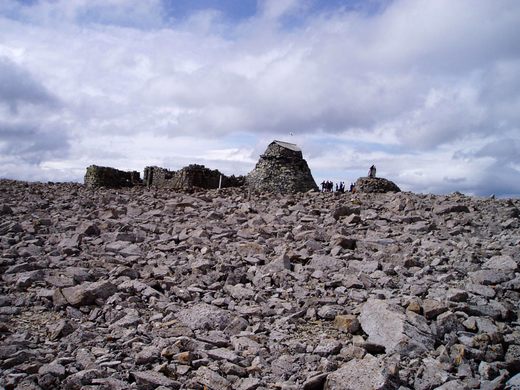
The observatory made its mark in history when one of the staff, C. T. R. Wilson, saw a Brocken specter, a meteorological optical illusion where an observers shadow appears to be a far off angelic form, and would later invent the cloud chamber (pretty much exactly like it sounds) to try and recreate it. Now the cloud chamber is an essential tool to detect ionizing radiation, and its invention won Wilson the 1927 Nobel Prize in physics. The ruins of the observatory still stand on the summit.
The Mountain Track has also seen ascents bringing odd items to the summit. In 1911 John Alexander drove a Model T Ford to the summit with the help of a team to drag it out of mud on the lower slopes. He would recreate the feat in 1928 with a Model A, and a replica was carried up by 71 people an assembled on the summit to celebrate the 100th anniversary of the drive. In 2006, a piano was found buried on the summit. Those wishing to take their own strange objects are advised to seek permission from the John Muir Trust which owns the mountain lands. The Trust regularly holds drives to clean the trails of rubbish which could damage the fragile ecosystem.
Climbers should also be prepared with a map and compass, for the summit area’s trails pass close to cliff edges, and clouds may blanket the summit at any time, which may lead hikers to choosing a wrong heading toward a treacherous route they are unprepared for, or even a cliff. Also, do not stand on any snow in the area, for it may overhang a cliff and send an unwary hiker to their death. A rare clear day affords incredible views of the entire Scottish Highlands from the highest point in the United Kingdom.
Many hikers who have tackled the 96 mile West Highland Way trek from Milngavie near Glasgow, then go on to hike Ben Nevis.
Community Contributors
Added by
Edited by
The Atlas Obscura Podcast is Back!


Follow us on Twitter to get the latest on the world's hidden wonders.
Like us on Facebook to get the latest on the world's hidden wonders.
Follow us on Twitter Like us on Facebook