Places Foods Stories Newsletters
Loading...
Loading...
Loading...

No search results found for
“”

Make sure words are spelled correctly.

Try searching for a travel destination.

Places near me Random place

Popular Destinations

  • Paris
  • London
  • New York
  • Berlin
  • Rome
  • Los Angeles
Places Foods Stories Newsletters
Sign In Join
Places near me Random place
All the United States Oregon Fremont Point

Fremont Point

Stay in an old lookout cabin atop Oregon's spectacular Winter Ridge.

Summer Lake, Oregon

slgwv profile photo
Added By
slgwv
Email
Been Here
Want to go
Added to list
CAPTION
The lookout cabin.   slgwv / Atlas Obscura User
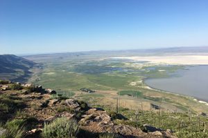
On Winter Ridge, looking south. Summer Lake in the valley to left.   slgwv / Atlas Obscura User
Looking east off Winter Ridge. Summer Lake below.   slgwv / Atlas Obscura User
Looking northeast off Winter Ridge. North edge of Summer Lake in the middle distance.   slgwv / Atlas Obscura User
Looking north along Winter Ridge.   slgwv / Atlas Obscura User
Looking down to Summer Lake off Winter Ridge.   slgwv / Atlas Obscura User
Interpretive sign about Fremont Point.   slgwv / Atlas Obscura User
Looking up to Fremont Point from Winter Ridge. The cabin is visible on the skyline to the left.   slgwv / Atlas Obscura User
Road to the cabin from the Fremont Point trailhead.   slgwv / Atlas Obscura User
Looking southeast off Winter Ridge. Summer Lake in the valley to the left.   slgwv / Atlas Obscura User
Looking northeast off Winter Ridge. North edge of Summer Lake in the middle distance.   slgwv / Atlas Obscura User
Looking southeast over Summer Lake.   slgwv / Atlas Obscura User
Been Here
Want to go
Added to list

About

Winter Ridge (also called Winter Rim) is a spectacular fault escarpment just to the west of (and nearly 3,000 feet above) Summer Lake. It's paralleled by Oregon State Route 31 on the east for around 22 miles, out in the Oregon Outback.

Winter Ridge was named by explorer John C. Frémont, who came through this area in December 1843. The expedition had already named the area Summer Lake, because it was unexpectedly warm for the time of year, so Winter Ridge was named in contrast. Frémont and the expedition had climbed up to this point to survey the area and to take stock of potential routes southward. They, like modern visitors, no doubt also appreciated the stunning views.

For many years the United States Forest Service maintained a fire lookout on Fremont Point, with an associated cabin to provide living quarters for the personnel stationed here. Alas, the lookout and cabin were both destroyed in the Winter Rim Wildfire of 2002.

The lookout was not replaced, but the cabin has been rebuilt to be a close replica of the original. It can now be rented as lodging, but be warned, that demand is high and reservations far in advance will almost certainly be required.

The cabin includes a stove and vault toilet, but no water; all water must be brought. The spectacular setting, however, goes a long way toward compensating for the primitive amenities.

Places

Discover your next amazing Atlas Place.

Get more unusual and extraordinary places each week with the Atlas Obscura Places newsletter.

Your newsletter subscriptions with us are subject to Atlas Obscura's Privacy Policy and Terms of Use.

Related Tags

Cabins Landscapes Geology

Know Before You Go

The easiest road access is from the north. Take US Forest Service road 290 16.2 miles from its junction with OR SR-31(at 43.02961 N, 120.79067 W) to its intersection with NF-3119. Turn left (east) here and go 2.3 miles to trailhead parking for the Fremont Trail, where there is a vault toilet but no other amenities. Continue beyond the trailhead another 0.3 miles up to the cabin. The distance is 18.8 miles overall.  These are graded roads, but can be washed out; high clearance may be required.

Although the cabin is supposed to be available year-round, there is no vehicle access in the winter except by snowmobile. Access on foot is permitted, but it's a long backcountry slog on skis or snowshoes that should be attempted only by those in excellent shape with backcountry experience.

The proximity of the Fremont Trail makes dayhikes along Winter Ridge especially attractive. You can start right out from the cabin door without getting in your vehicle.

Details about renting the cabin are on the website.

Community Contributors

slgwv profile photo

Added By

slgwv

Published

April 1, 2024

Edit this listing

Make an Edit
Add Photos
Fremont Point
Summer Lake, Oregon, 97640
United States
42.866245, -120.834374
Visit Website

Nearby Places

Paisley Five Mile Caves

Paisley, Oregon

miles away

Cowboy Dinner Tree

Silver Lake, Oregon

miles away

Fremont National Recreation Trail

Paisley, Oregon

miles away

Explore the Destination Guide

Photo of Oregon

Oregon

United States

Places 230
Stories 33

Nearby Places

Paisley Five Mile Caves

Paisley, Oregon

miles away

Cowboy Dinner Tree

Silver Lake, Oregon

miles away

Fremont National Recreation Trail

Paisley, Oregon

miles away

Explore the Destination Guide

Photo of Oregon

Oregon

United States

Places 230
Stories 33

Related Places

  • Land of Sleeping Volcanoes

    Kula, Turkey

    Land of Sleeping Volcanoes

    Stand on the rim of a dormant volcano and gaze across a vast ash plain frozen in time.

  • Window arch in the City of Rocks.

    Almo, Idaho

    City of Rocks

    This U.S. natural reserve is an ancient spiritual place and rock climber’s paradise.

  • View of Frank Triguero homestead site from the canyon rim.

    Bruneau, Idaho

    Bruneau Canyon

    The "Grand Canyon of Southwestern Idaho" makes a spectacular gash across the flat Snake River plain.

  • Rambla de Barrachina

    Villaspesa, Spain

    Rambla de Barrachina

    The geomorphology of the Turia Valley could easily be mistaken for Utah or Arizona.

  • Mexican Hat

    Mexican Hat, Utah

    Mexican Hat

    This balancing rock is one of Utah's most unusual geological formations.

  • Abert Rim from US-395 near Valley Falls.

    Valley Falls, Oregon

    Abert Rim

    This spectacular fault escarpment, a popular hang-glider launch point, extends some 30 miles long and towers about 2,500 feet over the valley floors to the west.

  • Great Salt Plains of Oklahoma

    Jet, Oklahoma

    Great Salt Plains

    This unique landscape is the only place in the world to dig for hourglass-selenite crystals.

  • The scarp south of Golconda Canyon.

    Winnemucca, Nevada

    Tobin Range (Pearce) Scarps

    The strongest earthquake in Nevada's recorded history left these spectacular breaks along the west front of a range in central Nevada.

Aerial image of Vietnam, displaying the picturesque rice terraces, characterized by their layered, verdant fields.
Atlas Obscura Membership

Become an Atlas Obscura Member


Join our community of curious explorers.

Become a Member

Get Our Email Newsletter

Follow Us

Facebook YouTube TikTok Instagram Pinterest RSS Feed

Get the app

Download the App
Download on the Apple App Store Get it on Google Play
  • All Places
  • Latest Places
  • Most Popular
  • Places to Eat
  • Random
  • Nearby
  • Add a Place
  • Stories
  • Food & Drink
  • Itineraries
  • Lists
  • Video
  • Podcast
  • Newsletters
  • All Trips
  • Membership
  • Feedback & Ideas
  • Community Guidelines
  • Product Blog
  • Unique Gifts
  • Work With Us
  • About
  • FAQ
  • Advertise With Us
  • Advertising Guidelines
  • Privacy Policy
  • Cookie Policy
  • Terms of Use
Atlas Obscura

© 2026 Atlas Obscura. All Rights Reserved.