Trips Places Foods Stories Newsletters
Loading...
Loading...
Loading...
Loading...

No search results found for
“”

Make sure words are spelled correctly.

Try searching for a travel destination.

Places near me Random place

Popular Destinations

  • Paris
  • London
  • New York
  • Berlin
  • Rome
  • Los Angeles
Trips Places Foods Stories Newsletters
Sign In Join
Places near me Random place
All the United States Colorado Buena Vista Mount Elbert
AO Edited

Mount Elbert

At the tallest peak in Colorado, an electrifying mix of thin air, lightning, and rivalry.

Buena Vista, Colorado

Added By
Thomas Harper
Email
Been Here
Want to go
Added to list
CAPTION
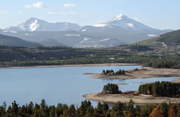
Mount Elbert reflecting in Twin Lakes   Getty Images/Lightvision, LLC
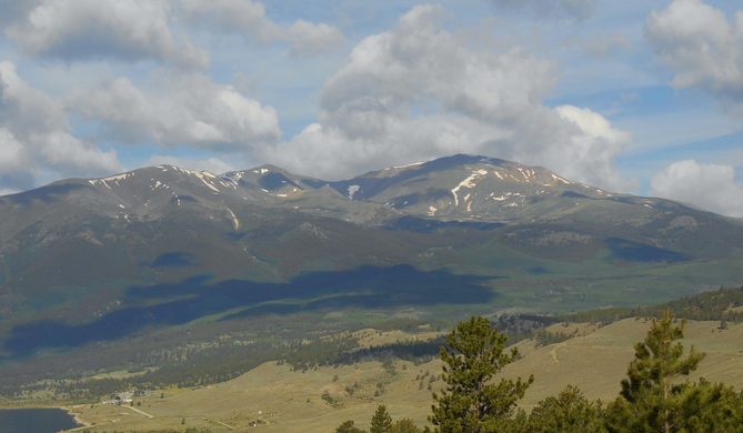
The summit of Mt Elbert as viewed from Half Moon Creek, northeast of the trailhead.   simpsonamanda8 / Atlas Obscura User
  simpsonamanda8 / Atlas Obscura User
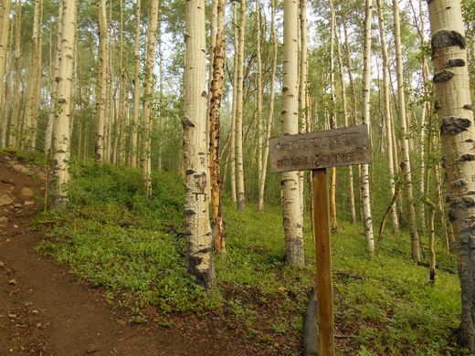
Trail Through an Aspen Grove   thomasharper / Atlas Obscura User
Mount Elbert   thomasharper / Atlas Obscura User
Hiking up Elbert, one encounters a couple of false summits, like the one pictured here. The actual summit is approximately 600 vertical feet above this false summit.   simpsonamanda8 / Atlas Obscura User
Summit  
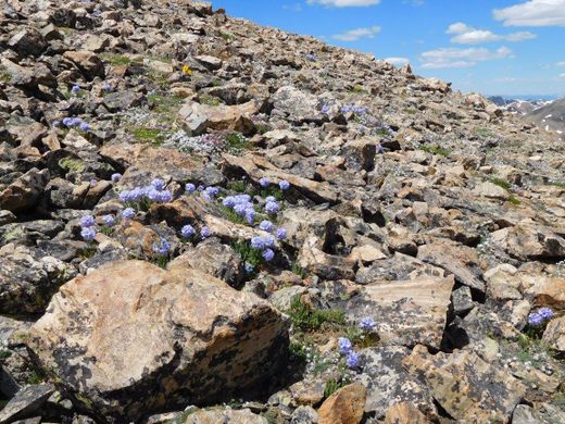
Above treeline, wildflowers peek out of the rocks.   simpsonamanda8 / Atlas Obscura User
5-7-22   Darrell Powers / Atlas Obscura User
Been Here
Want to go
Added to list

About

The highest point in Colorado and the Rocky Mountains, Mount Elbert at 14,440 feet above sea level, can be a straightforward hike. Just be aware of altitude sickness and afternoon lightning, and maybe supporters of another nearby mountain.

Rising above all others in the Rocky Mountains, and the second-highest peak in the continental United States, the ascent up Mount Elbert on its simplest route can be a moderate four-mile hike to the summit. In the 1970s, supporters of the second-highest mountain in the Rockies, the nearby Mount Massive at just 12 feet shorter, would pile rocks on a cairn at the summit to bring it above Elbert because it is a more "deserving" peak with a much harder climb, a 7.8-mile scramble gaining over 4,500 vertical feet. Elbert supporters, however, would climb Massive and tear the cairn down.

The standard route up this mountain, the South Mount Elbert Trail, is a gentle gradient through the San Isabel National Forest, filled with pines and aspen until the tree line. While the hike may be gentle, there are other concerns. Gray clouds with lightning develop near the peak almost daily from July through mid-August. If clouds develop, turn around, for the highest point in the Rockies is not the place to be when lightning strikes. Also, if a hiker is not used to the altitude and lower concentration of oxygen, the hiker may get a splitting headache that aspirin will not alleviate, and that could lead to a high altitude pulmonary or cerebral edema, which is fatal when no emergency services are available for miles. If a headache occurs and gets worse as one ascends, turn around.

Related Tags

Mountains Geographic Markers State High Points

Know Before You Go

From Twin Lakes, Colorado, take Lake County Route 24 to the singed parking lot for the South Mt. Elbert Trailhead and hike 5 miles to the summit. Alternatively, with a 4WD vehicle, turn left at this trailhead onto road 125B and follow it for 2 miles to clearings. Park and take the Colorado Trail, signed 125C, to its junction with the South Mt. Elbert Trail. Hike over 3 miles to the summit.

Community Contributors

Added By

thomasharper

Edited By

kendallrmnp, crystaldawnwylie, simpsonamanda8, Michelle Cassidy...

  • kendallrmnp
  • crystaldawnwylie
  • simpsonamanda8
  • Michelle Cassidy
  • Darrell Powers

Published

July 23, 2014

Edit this listing

Make an Edit
Add Photos
Sources
  • https://www.fs.usda.gov/recarea/psicc/recreation/recarea/?recid=12506&actid=50
  • https://en.wikipedia.org/wiki/Mount_Elbert
  • http://en.wikipedia.org/wiki/Mount_Elbert
  • http://www.summitpost.org/mount-elbert/150325
Mount Elbert
Buena Vista, Colorado, 81211
United States
39.117769, -106.445305

Nearby Places

Irish Miners' Memorial and Cemetery

Leadville, Colorado

miles away

Temple Israel Museum

Leadville, Colorado

miles away

House With the Eye Museum

Leadville, Colorado

miles away

Explore the Destination Guide

Photo of Colorado

Colorado

United States

Places 311
Stories 31

Nearby Places

Irish Miners' Memorial and Cemetery

Leadville, Colorado

miles away

Temple Israel Museum

Leadville, Colorado

miles away

House With the Eye Museum

Leadville, Colorado

miles away

Explore the Destination Guide

Photo of Colorado

Colorado

United States

Places 311
Stories 31

Related Stories and Lists

The Highest Places in America

List

By Meg Neal

Related Places

  • Mount Denali

    Denali National Park and Preserve, Alaska

    Denali

    The king of U.S. high points towers over every other peak on the continent.

  • Mount Rainier

    Ashford, Washington

    Mount Rainier

    The highest point in Washington state is a volcano covered in glaciers.

  • Mount Hood

    Government Camp, Oregon

    Mount Hood

    Despite a legend that says this highest peak in Oregon was climbed in high heels, scores of people have died on its slopes.

  • Gannett Peak

    Cora, Wyoming

    Gannett Peak

    The easiest way to the highest point in Wyoming is only accessible via one hefty fee.

  • Granite Peak

    Granite Peak

    The highest point in Montana is as rugged and singular as the state itself.

  • Borah Peak

    Mackay, Idaho

    Borah Peak

    This highest peak in Idaho can only be reached by traversing a formation known as "Chicken-Out Ridge."

  • Kings Peak

    Duchesne County, Utah

    Kings Peak

    The highest peak in Utah is the hardest to reach, but only if explorers choose the hard way.

  • Wheeler Peak

    Taos Ski Valley, New Mexico

    Wheeler Peak

    This highest peak in New Mexico is named after an explorer who had a habit of lending his moniker to peaks.

Aerial image of Vietnam, displaying the picturesque rice terraces, characterized by their layered, verdant fields.
Atlas Obscura Membership

Become an Atlas Obscura Member


Join our community of curious explorers.

Become a Member

Get Our Email Newsletter

Follow Us

Facebook YouTube TikTok Instagram Pinterest RSS Feed

Get the app

Download the App
Download on the Apple App Store Get it on Google Play
  • All Places
  • Latest Places
  • Most Popular
  • Places to Eat
  • Random
  • Nearby
  • Add a Place
  • Stories
  • Food & Drink
  • Itineraries
  • Lists
  • Video
  • Podcast
  • Newsletters
  • All Trips
  • Family Trip
  • Food & Drink
  • History & Culture
  • Wildlife & Nature
  • FAQ
  • Membership
  • Feedback & Ideas
  • Community Guidelines
  • Product Blog
  • Unique Gifts
  • Work With Us
  • About
  • FAQ
  • Advertise With Us
  • Advertising Guidelines
  • Privacy Policy
  • Cookie Policy
  • Terms of Use
Atlas Obscura

© 2025 Atlas Obscura. All Rights Reserved.