Places Foods Stories Newsletters
Loading...
Loading...
Recent Stories
All Stories Video Podcast
Most Recent Stories
View All Stories »
Check Out the Playlist for Our New Book
To Andrew Phung, Calgary is simultaneously a big city and a small town—in all the right ways.
Andrew Phung’s Favorite Calgary Spots
One of the gargoyles that adorns Oxford’s Magdalen College.
8 Gargoyles and Grotesques Hiding in Plain Sight
Only-in-Anchorage Winter Traditions

No search results found for
“”

Make sure words are spelled correctly.

Try searching for a travel destination.

Places near me Random place

Popular Destinations

  • Paris
  • London
  • New York
  • Berlin
  • Rome
  • Los Angeles
Places Foods Stories Newsletters
Sign In Join
Places near me Random place
All the United States North Carolina Forneys Creek Tail of the Dragon
AO Edited

Tail of the Dragon

This winding road of 318 curves is a must-visit for (careful) motorcycle and sports car enthusiasts.

Forneys Creek, North Carolina

KenJ profile photo
Added By
Ken J
Email
Been Here
Want to go
Added to list
CAPTION
A few easy turns.   William Klos/cc by 2.0
Cheoah Dam from the bottom of the Dragon.  
Remains of an old house in the now defunct town of Calderwood.  
Black bear asleep in the trees on the Dragon.  
The "bend" as seen from the Overlook.  
The sign at the Dragon Store.  
A Triumph TR6 having fun on the Dragon.  
Small waterfall from the side of the Dragon.  
View of Calderwood Dam from the Overlook.  
Small group of British sports cars enjoying the dragon.  
Cheoah Dam Powerhouse from the bottom of the Dragon.  
Cheoah Dam from the bottom of the Dragon.  
Old Roadbed normally under the Calderwood Lake.  
Tail of the Dragon   Phantoms Secret / Atlas Obscura User
  Collector of Experiences / Atlas Obscura User
Cheoah Dam from the bottom of the Dragon.  
  Collector of Experiences / Atlas Obscura User
Been Here
Want to go
Added to list

About

Highway 129 crosses along the beautiful, rugged southwestern border of the Great Smokey Mountains National Park. The highway's collection of turns and bends have earned it the nickname "Dragon's Tail." Along this stretch of road are drastic curves with names such as "Beginner's End" and "Gravity Cavity." These nicknames aren't meant to be taken lightly, as accidents along the highway are frequent. 

Commercial trucks with a trailer longer than 30 feet are forbidden from operating along this stretch of highway. Truck drivers may even lose their commercial driver's license for attempting to traverse the dangerous highway. With this lack of commercial traffic, Highway 129 is a tempting destination for motorcycle and sports car lovers from across the globe.

The highway is so popular that several companies run photo services along the route catering to adventurous motorists. Simply drive the road on any summer day and your photo will be taken numerous times and available to purchase online. 

The route was originally used by the native Cherokee and herds of roaming buffalo before it become an official Tennessee route in the 1920s. The road was named TN72 on the Tennessee side. It was seldom used until the mid-1990s, when motorcycle and sport car communities began to take notice.

At the southern end of the roadway in North Carolina, two permanent stores across from each other offer a number of souvenirs, t-shirts, and cold drinks.  It's considered bad luck by some to buy souvenirs or put dragon stickers on your vehicle until you've actually traversed the road safely. The shops are seasonal and are only open during the spring and summer months.  During these months anticipate heavy traffic along the popular roadway.  

Places

Discover your next amazing Atlas Place.

Get more unusual and extraordinary places each week with the Atlas Obscura Places newsletter.

Your newsletter subscriptions with us are subject to Atlas Obscura's Privacy Policy and Terms of Use.

Know Before You Go

The speed limit has dropped from 55 miles per hour to 30 miles per hour and is frequently patrolled for traffic violations. Bring your action camera and motion sickness pills. Keep in mind that rescue squads can take up to an hour to reach the location of a wreck. Double yellow lines means do not pass. Keep an eye out for weekend daredevils. Cabins, restaurants, and shops can be found at either end of this stretch.

Community Contributors

KenJ profile photo

Added By

KenJ

iantheindescribable profile photo P Phantoms Secret profile photo

Edited By

iantheindescribable, Phantoms Secret

  • iantheindescribable profile photo iantheindescribable
  • P Phantoms Secret profile photo Phantoms Secret

Published

September 4, 2019
Edit this listing

Make an Edit
Add Photos
Sources
  • https://en.wikipedia.org/wiki/Two-Lane_Blacktop
  • https://en.wikipedia.org/wiki/Deals_Gap,_North_Carolina
  • https://tailofthedragon.com/trucks-on-the-dragon/
  • https://en.wikipedia.org/wiki/The_Fugitive_(1993_film)#Filming
  • https://tailofthedragon.com/

Related Tags

Roads National Parks
Tail of the Dragon
Forneys Creek, North Carolina, 37885
United States
35.474048, -83.92101

Nearby Places

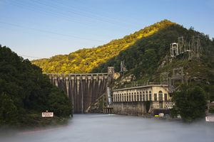
Cheoah Dam

Robbinsville, North Carolina

miles away

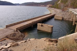
Abrams Creek Underwater Bridge

Tallassee, Tennessee

miles away

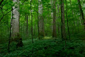
Joyce Kilmer Memorial Forest

Robbinsville, North Carolina

miles away

Explore the Destination Guide

Photo of North Carolina

North Carolina

United States

Places 227
Stories 37

Related Stories and Lists

The Ultimate Guide to America's National Parks

List

By Atlas Obscura

Related Places

  • Hotel Natura Patagonia in Peulla, Chile

    Peulla, Chile

    Peulla

    This secluded village in the Andean wilderness can't be accessed by road.

  • Sunset on Stanage Edge

    Derbyshire, England

    Stanage Edge

    This iconic Peak District ridge was once one of the busiest roads in medieval Britain.

  • Marker at the end of National Route 3, Bahia Lapataia.

    Ushuaia, Argentina

    Bahia Lapataia at the End of the World

    The most southern point you can drive to in the Western Hemisphere.

  • The Arctic Circle Centre.

    Storforshei, Norway

    Arctic Circle Centre

    This roadside attraction looks like a flying saucer parked atop the tundra.

  • The ruins of the Ritter Lumber Company's sawmill at Hazel Creek near Proctor.

    Bryson City, North Carolina

    The Lost Town of Proctor

    The scant remains of this flooded historic village can be explored in one of the most remote areas of the Great Smokies.

  • Tunnel at the end of the road.

    Bryson City, North Carolina

    The Road to Nowhere

    This road in the Great Smoky Mountains was supposed to assuage a displaced community, but ended up a $52 million dead end.

  • View of the Missing Cabin

    Jemez Springs, New Mexico

    ‘The Missing’ Cabin

    What appears to be a historic cabin nestled within Valles Caldera National Preserve is actually part of an abandoned movie set.

  • The crossing in summertime

    Tajikistan

    Longest Road Through No Man’s Land

    The Pamir Highway between Tajikistan and Kyrgyzstan takes a mere hour driving through a stretch of No Man’s Land.

Aerial image of Vietnam, displaying the picturesque rice terraces, characterized by their layered, verdant fields.
Atlas Obscura Membership

Become an Atlas Obscura Member


Join our community of curious explorers.

Become a Member

Get Our Email Newsletter

Follow Us

Facebook YouTube TikTok Instagram Pinterest RSS Feed

Get the app

Download the App
Download on the Apple App Store Get it on Google Play
  • All Places
  • Latest Places
  • Most Popular
  • Places to Eat
  • Random
  • Nearby
  • Add a Place
  • Stories
  • Food & Drink
  • Itineraries
  • Lists
  • Video
  • Podcast
  • Newsletters
  • All Trips
  • Membership
  • Feedback & Ideas
  • Community Guidelines
  • Product Blog
  • Unique Gifts
  • Work With Us
  • About
  • FAQ
  • Advertise With Us
  • Advertising Guidelines
  • Privacy Policy
  • Cookie Policy
  • Terms of Use
Atlas Obscura

© 2026 Atlas Obscura. All Rights Reserved.