About
Many political boundaries in the western US, as around the world, were drawn along lines of latitude or longitude. This was convenient for politicians looking at maps, but it's much easier to draw a line on the map than to establish that line on the ground—particularly with 19th-century technology.
The mutual corner of Arizona, Utah, and Nevada is a case in point. In theory the boundary of Utah and Arizona is the 37th parallel of latitude, while the eastern boundary of Nevada lies along the meridian at 114° 2' W (or 114.03333 W in decimal degrees). This point was first surveyed in 1870 by Isaac P. James, described as an "astronomer and surveyor." The juxtaposition seems unlikely now, but astronomy was traditionally important to establishing positions on the Earth because latitude could be determined by measuring the angle of known stars above the horizon. Longitude, in turn, could be determined by the time of local noon (when the Sun is highest in the sky) versus the time of noon at a reference point, such as Greenwich, England. The problem was that such measurements were difficult in a survey carried out on horseback under primitive conditions. Longitude in particular, which depended on precise measurements of time, was subject to large errors.
For such reasons this point was resurveyed in 1900 and found to be in significant error, with the James monument at the 37th parallel being 111.51 chains too far north. (A "chain" is 66 feet, so there are 80 chains in a mile. In other words, the location was nearly 1.5 miles too far north.)
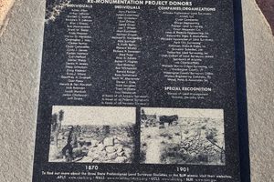
The 1900 resurvey (monumented in 1901) was a considerable improvement over the original James survey, but over time it became clear that it was still a bit off. At a surveyors' convention in 2016, the Utah Council of Land Surveyors proposed re-monumenting the Tri-State Monument, in collaboration with the state survey societies of Arizona and Nevada. This proposal met with enthusiastic acceptance and the tri-point was resurveyed with new technology: GPS with sub-centimeter accuracy. The 1901 monument was removed (it is now on display in the Washington County Administration Office in St. George, Utah) and the current one constructed. Presumably further resurveys will not be needed!
Know Before You Go
The Tri-Point is reached on dirt roads. High clearance will be required in places and 4WD will be needed to go all the way to the monument.
The best access is as follows. Take Exit 8 off Interstate 15 into Littlefield and go north on Arizona State Route 91 (old US-91). Turn left (west) onto Rincon Road at the 4-way stop just north of the freeway. Continue 0.8 mile, parallel to I-15, to where the pavement turns north and becomes Virgin Acres Boulevard. Do not follow the pavement but cross onto the obvious dirt road to the northwest, which is County Road 3454. From here high clearance will be appreciated if not always required. Go 4.1 miles to a junction at about 36.90207 N, 114.01002 W. Turn right here and go 3.6 miles to a junction at about 36.953220 N, 114.00758 W. Make a shallow left here. Go 3.8 miles, staying on the main road as it winds around, to an intersection at 36.94901 N, 114.06254 W, which is Sand Hollow Road. Turn right onto Sand Hollow Road. Go 4.5 miles to an intersection at about 37.007765 N, 114.08591 W. You are now on Terry Bench Road. Turn right here and go 0.1 mile to a primitive road and turn right (at about 37.00884 N, 114.08391 W). High clearance will definitely be needed on this road and perhaps 4WD will be needed, too. Go 2.0 miles on this road, which is nearly straight, to a junction at 36.99839 N, 114.05004 W and turn left (north). It is now only about 670 feet to the monument. Four-wheel-drive will probably be needed to drive the whole way from this point, but in any case it's now an easy walk. The monument, which has all three state flags plus the national flag, will be easy to spot.
There are occasional small signs along these roads that give directions to the Tri-State Monument, but they should not be relied upon as they're not always present.
Community Contributors

Added By
Published
August 7, 2026