Trips Places Foods Stories Newsletters
Loading...
Loading...
Loading...
Loading...

No search results found for
“”

Make sure words are spelled correctly.

Try searching for a travel destination.

Places near me Random place

Popular Destinations

  • Paris
  • London
  • New York
  • Berlin
  • Rome
  • Los Angeles
Trips Places Foods Stories Newsletters
Sign In Join
Places near me Random place
All Spain Asturias Cares Gorge

Cares Gorge

A spectacular walk on the flank of a gorge.

Asturias, Spain

Added By
dubh
Email
Been Here
Want to go
Added to list
CAPTION
Cares Gorge   dubh / Atlas Obscura User
  Suryo / Atlas Obscura User
  Suryo / Atlas Obscura User
The sign leading to the Cares trail.   dubh / Atlas Obscura User
  Carole England / Atlas Obscura User
Been Here
Want to go
Added to list

About

Known as the “Divine Throat”, this route between Caín (León) and Poncebos (Asturias) will allow you to walk between mountains that rise to more than 2,000 meters above the bottom of the imposing gorge carved out by the River Cares. You will see mythical peaks, you will pass through bridges that connect both sides of the gorge, you will go through around 70 tunnels carved into the rock and you will witness an amazing natural spectacle.

This deep gorge is not only the work of the natural force of the waters of the Cares River. It is also the result of engineering work that was carried out in the early 20th century to transport water to the Poncebos hydroelectric power station. Thanks to this, today it is easy to do this pleasant walk—you just have to follow the channel.

If you are an experienced hiker, you will be interested to know that the official route (PR-PNP 3) really starts (or ends) in Posada de Valdeón (León) and not in Caín, so the route becomes much longer (21 kilometers one way). However, this first section has fallen into disuse and the most frequent is to start in Caín.

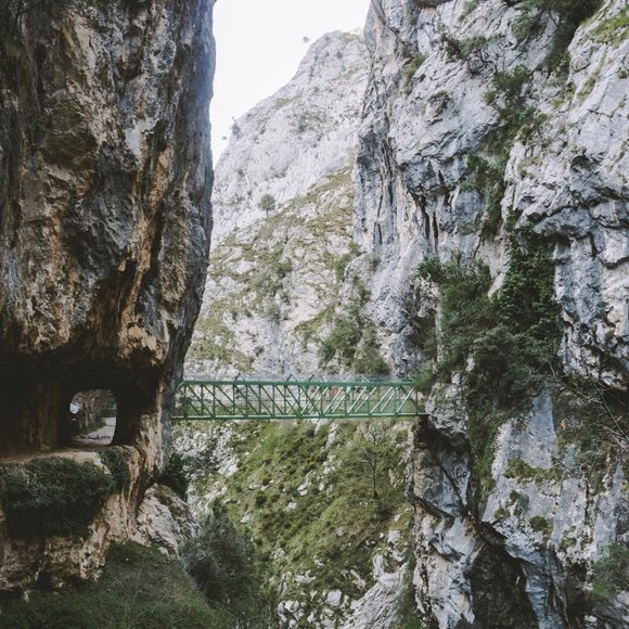
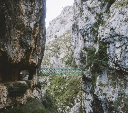
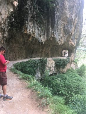
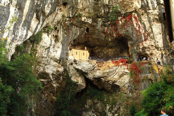
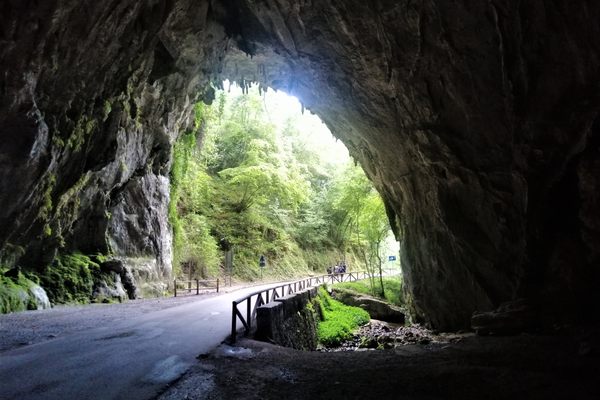
The walk starts off innocently enough, meandering along the banks of the Rio Cares. The path soon morphs into the old hydroelectric maintenance track, which is carved into the cliff face. You soon gain altitude and can see the Cares River's unrelenting erosion of limestone that helped form the gorge. You will see a natural arch, dramatic cliffs, and enjoy the shade of the oak and chestnut trees that grow here. Goats and vultures are the most common animals you will see.

As the train nears Caín, the gorge gets more and more narrow, until you walk through a dark canyon filled with the roar of the rushing river. In Caín, there are several options to eat and drink by the river. The village itself is situated in a valley with steep sides, with many walnut trees growing all around it.

Related Tags

Hiking Trail Mountains Rivers

Know Before You Go

The views are beautiful. The trek takes about eight hours to the end and back. Sensible footwear is a must along with clothing to suit the weather. Pack lunch and water as well as walking poles to steady yourself along the path.

The hike connects the villages of Poncebos in Asturias and Caín in León. It is 12 km long, but in all likelihood, you will walk it back to where you started, so it’s 24 km. Should you decide that you’re unable or unwilling to walk back and take a taxi to your starting point: the drive between the two villages is about 120 km long. That is, if you can get a taxi, because neither village is exactly big.

Almost all hikers start at the trailhead in Poncebos. Make sure to arrive early to find a convenient place to park your car. You can buy packaged lunches at several places along the way in Poncebos.

Starting in Poncebos also means that you will begin the hike with the steepest parts of the trail and don’t have to do that on the way back.

Community Contributors

Added By

dubh

Edited By

Suryo, Carole England, jeop60

  • Suryo
  • Carole England
  • jeop60

Published

July 7, 2019

Edit this listing

Make an Edit
Add Photos
Sources
  • https://www.turismoasturias.es/descubre/naturaleza/rutas/senderismo/ruta-del-cares
  • https://www.turismocastillayleon.com/es/rural-naturaleza/rutas-naturaleza/ruta-cares
  • https://www.spain.info/es/rutas-senderismo/ruta-del-cares-senderismo-espana/
  • https://rutacares.org/
Cares Gorge
Ruta del Cares
Asturias
Spain
43.25385, -4.83751
Get Directions

Nearby Places

Cantabrian Chamois of Asturias

Posada de Valdeón, Spain

miles away

Holy Cave of Covadonga

Asturias, Spain

miles away

Bufones de Arenillas

Llanes, Spain

miles away

Explore the Destination Guide

Photo of Asturias

Asturias

Spain

Places 5

Nearby Places

Cantabrian Chamois of Asturias

Posada de Valdeón, Spain

miles away

Holy Cave of Covadonga

Asturias, Spain

miles away

Bufones de Arenillas

Llanes, Spain

miles away

Explore the Destination Guide

Photo of Asturias

Asturias

Spain

Places 5

Related Places

  • The view of the Blue Ridge Mountains here is spectacular.

    Canton, North Carolina

    Black Balsam Knob

    On a clear afternoon, you can see mountain peaks more than 40 miles away from this clearing in the Pisgah National Forest.

  • Vacant since the 1960s, this tower still offers the best view around.

    Cosby, Tennessee

    Mount Cammerer Lookout Tower

    Trek up to an abandoned fire lookout from the 1930s for an unimpeded view.

  • Geneva, Switzerland

    Pointe de la Jonction

    Where two rivers meet—but don’t mix.

  • Mesetas, Colombia

    Cañon del Guejar (Güejar River Canyon)

    River raft through rural Colombia’s ancient rock formations, pristine landscapes, and towering waterfalls.

  • Memorials at the symbolic cemetery

    Vysoké Tatry, Slovakia

    Symbolic Cemetery at Popradské Pleso

    A serene memorial that honors the adventurous spirits of climbers who lost their lives in the High Tatras.

  • View of Frank Triguero homestead site from the canyon rim.

    Bruneau, Idaho

    Bruneau Canyon

    The "Grand Canyon of Southwestern Idaho" makes a spectacular gash across the flat Snake River plain.

  • Looking north along Winter Ridge.  Summer Lake on the right.

    Paisley, Oregon

    Fremont National Recreation Trail

    A remote trail traverses the little-known Gearhart Mountains of southern Oregon.

  • An archway superimposes mountaineers made of metal over the visage of Pike’s Peak.

    Colorado Springs, Colorado

    AdAmAn Alley

    An unexpected alley with light shows and nature views.

Aerial image of Vietnam, displaying the picturesque rice terraces, characterized by their layered, verdant fields.
Atlas Obscura Membership

Become an Atlas Obscura Member


Join our community of curious explorers.

Become a Member

Get Our Email Newsletter

Follow Us

Facebook YouTube TikTok Instagram Pinterest RSS Feed

Get the app

Download the App
Download on the Apple App Store Get it on Google Play
  • All Places
  • Latest Places
  • Most Popular
  • Places to Eat
  • Random
  • Nearby
  • Add a Place
  • Stories
  • Food & Drink
  • Itineraries
  • Lists
  • Video
  • Podcast
  • Newsletters
  • All Trips
  • Family Trip
  • Food & Drink
  • History & Culture
  • Wildlife & Nature
  • FAQ
  • Membership
  • Feedback & Ideas
  • Community Guidelines
  • Product Blog
  • Unique Gifts
  • Work With Us
  • About
  • FAQ
  • Advertise With Us
  • Advertising Guidelines
  • Privacy Policy
  • Cookie Policy
  • Terms of Use
Atlas Obscura

© 2025 Atlas Obscura. All Rights Reserved.