Trips Places Foods Stories Newsletters
Loading...
Top Destinations
Latest Places
Most Popular Places Random Place Lists Itineraries
Add a Place
Download the App
Top Destinations
View All Destinations »

Countries

  • Australia
  • Canada
  • China
  • France
  • Germany
  • India
  • Italy
  • Japan

Cities

  • Amsterdam
  • Barcelona
  • Beijing
  • Berlin
  • Boston
  • Budapest
  • Chicago
  • London
  • Los Angeles
  • Mexico City
  • Montreal
  • Moscow
  • New Orleans
  • New York City
  • Paris
  • Philadelphia
  • Rome
  • San Francisco
  • Seattle
  • Stockholm
  • Tokyo
  • Toronto
  • Vienna
  • Washington, D.C.
Latest Places
View All Places »
Though the dam crest is long gone, the tower still stands.
Den Hvide Jomfru (The White Maiden)
The front of the mosque.
Şakirin Mosque
Ornate decorations are part of some of the music boxes.
Terranova Music Box Museum
Take some of Michigan’s produce home with you.
American Spoon
Latest Places to Eat & Drink
View All Places to Eat »
Take some of Michigan’s produce home with you.
American Spoon
The local catch is delicious fried as well.
Terry's of Charlevoix
Carlson’s Fishery is a Great Lakes institution.
Carlson’s Fishery
Books are available inside for borrowing or purchase.
Cathedral Café
Exterior of the historic Dyffryn Arms pub.
Dyffryn Arms
Loading...

No search results found for
“”

Make sure words are spelled correctly.

Try searching for a travel destination.

Places near me Random place

Popular Destinations

  • Paris
  • London
  • New York
  • Berlin
  • Rome
  • Los Angeles
Trips Places Foods Stories Newsletters
Sign In Join
Places near me Random place
All the United States Pennsylvania Pittsburgh Allegheny County Belt System

Allegheny County Belt System

Color-coded signs direct drivers on a network of routes designed to avoid Pittsburgh traffic.

Pittsburgh, Pennsylvania

Added By
Thomas Harper
Email
Been Here
Want to go
Added to list
CAPTION
Green Belt sign in Emsworth.   thomasharper / Atlas Obscura User
Purple Belt sign on Stanwix Street.   thomasharper / Atlas Obscura User
Blue Belt sign in McKees Rocks.   thomasharper / Atlas Obscura User
Yellow Belt sign in Coraopolis.   thomasharper / Atlas Obscura User
Orange Belt sign at the Sewickley Bridge.   thomasharper / Atlas Obscura User
Red Belt sign in Leetsdale.   thomasharper / Atlas Obscura User
A map of the belt system.   Alekjds/CC BY-SA 3.0
  chasepopt / Atlas Obscura User
Been Here
Want to go
Added to list

About

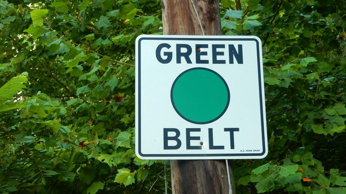
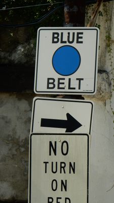
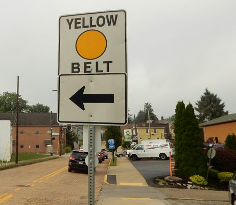
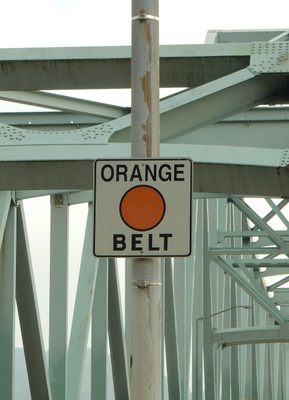
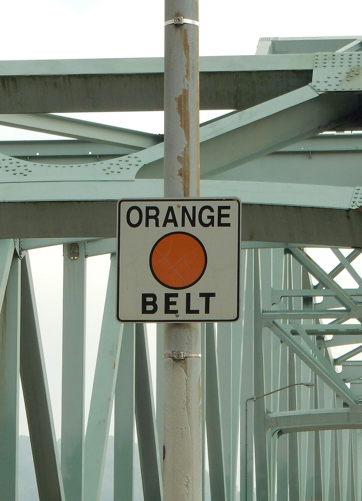
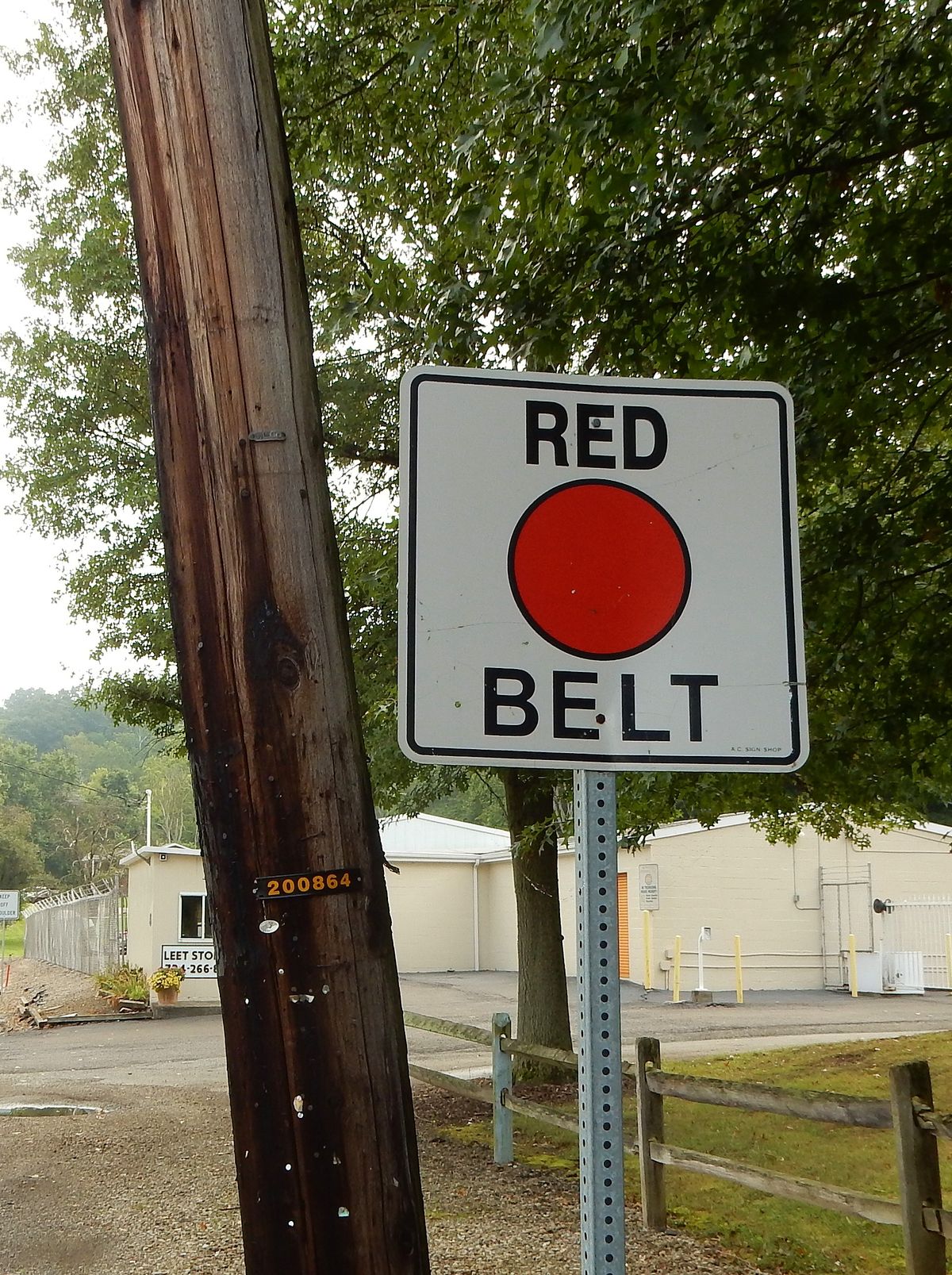
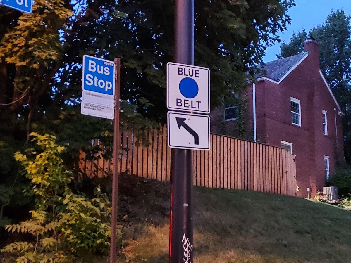
While the Pittsburgh metropolitan area lacks a dedicated beltway (ring road) system surrounding the city, urban travelers have another way to circumvent its traffic. Since the 1950s, a series of signs with large, colored circles signify "belts" that wend their way through various towns and suburbs in the hills of Allegheny County, Pennsylvania.

Pittsburgh's major highways (known as the Parkways North, East, and West) direct highway traffic straight toward the downtown area of the city, and there are no nearby expressways in the surrounding area. When Pittsburgh's increasingly congested traffic continued to grow during the steel boom, an engineer with the county, Joseph White, laid out different routes around the city to help mediate the issue, making a belt system.

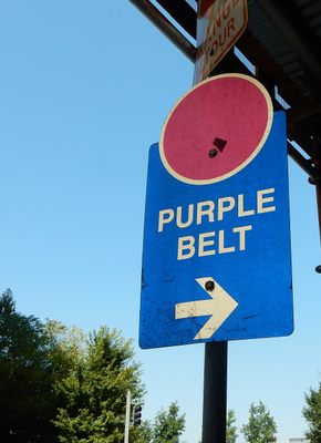
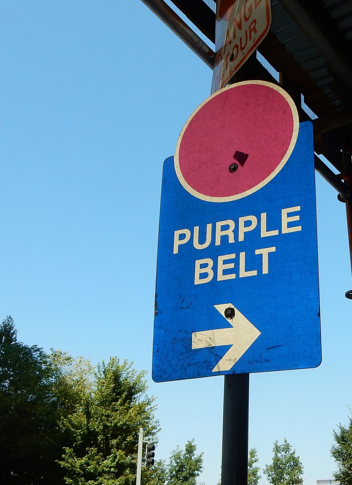
These paths meander through various suburbs and towns on the outskirts of Pittsburgh and can be used as a navigational aid. The routes were marked with signs with large, colorful dots, with the Red Belt being outermost and the Blue Belt close to the city. In the 1990s, the city itself added a Purple Belt downtown as a nod to the color-coded navigational network and as part of the Pittsburgh Wayfinder System.

While some in the area may see the belt system as irrelevant, the signs are still standing and continue to be maintained across the county, directing travelers on secluded routes around traffic.

Related Tags

Infrastructure Roads Urban Planning Cars Color Signs Cities Industrial Geographic Markers Navigation

Know Before You Go

Only one Purple Belt sign remains at the given address. All other belts can be accessed by PA Route 65. Just look for the signs.

Community Contributors

Added By

thomasharper

Edited By

chasepopt

  • chasepopt

Published

August 24, 2017

Edit this listing

Make an Edit
Add Photos
Sources
  • https://en.wikipedia.org/wiki/Allegheny_County_belt_system
  • http://www.post-gazette.com/in-the-lead-2014-stories/2014/05/13/Infrastructure-Nay-to-a-Pittsburgh-beltway/stories/201405150085
Allegheny County Belt System
630 Stanwix Street
Pittsburgh, Pennsylvania
United States
40.443177, -80.004281
Get Directions

Nearby Places

Pittsburgh's Snoopy Doghouse

Pittsburgh, Pennsylvania

miles away

Fort Pitt Blockhouse

Pittsburgh, Pennsylvania

miles away

Former Pittsburgh Stock Exchange

Pittsburgh, Pennsylvania

miles away

Explore the Destination Guide

Photo of Pittsburgh

Pittsburgh

Pennsylvania

Places 61
Stories 5

Related Places

  • The Katarinahissen.

    Stockholm, Sweden

    Katarina Elevator

    This gem from the industrial age helps visitors and residents alike traverse hilly Stockholm.

  • Cromwell’s Corners was once called Murdering Lane.

    Dublin, Ireland

    Murdering Lane and Cutthroat Lane

    Though they've since been renamed, these two streets hint at Dublin's darker days.

  • Rotterdam, Netherlands

    Street Posts Museum

    An unexpected public exhibit showcases the diversity of Dutch street posts.

  • Brussels, Belgium

    Largest Paving Stone in Belgium

    This huge limestone slab is considered the largest paving stone in Belgium and a relic of the earliest modern paving in Brussels.

  • The Rainbow Crosswalk is paved with a familiar Art Deco pattern in colors chosen from Leonard Horowitz’s palette.

    Miami Beach, Florida

    The Rainbow Crosswalk

    This Ocean Drive crosswalk has been paved in rainbow colors to honor the LGBTQ+ community and the man who brought pastel to Miami Beach.

  • Sign for L13

    Mannheim, Germany

    Mannheim Quadratestadt

    In this German city center, the streets have no names.

  • The sign before it was covered in stickers.

    Chicago, Illinois

    Beginning (and End) of Historic Route 66

    A journey begins with a single step, and for many, the road-trip of a lifetime started at this Chicago intersection.

  • Chequer Street Wooden Paving

    London, England

    Chequer Street Wooden Paving

    This may be the last of London's wooden pavements, which were once a common sight in the city.

Aerial image of Vietnam, displaying the picturesque rice terraces, characterized by their layered, verdant fields.
Atlas Obscura Membership

Become an Atlas Obscura Member


Join our community of curious explorers.

Become a Member

Get Our Email Newsletter

Follow Us

Facebook YouTube TikTok Instagram Pinterest RSS Feed

Get the app

Download the App
Download on the Apple App Store Get it on Google Play
  • All Places
  • Latest Places
  • Most Popular
  • Places to Eat
  • Random
  • Nearby
  • Add a Place
  • Stories
  • Food & Drink
  • Itineraries
  • Lists
  • Video
  • Podcast
  • Newsletters
  • All Trips
  • Family Trip
  • Food & Drink
  • History & Culture
  • Wildlife & Nature
  • FAQ
  • Membership
  • Feedback & Ideas
  • Community Guidelines
  • Product Blog
  • Unique Gifts
  • Work With Us
  • About
  • FAQ
  • Advertise With Us
  • Advertising Guidelines
  • Privacy Policy
  • Cookie Policy
  • Terms of Use
Atlas Obscura

© 2025 Atlas Obscura. All Rights Reserved.