Places Foods Stories Newsletters
Loading...
Loading...
Loading...

No search results found for
“”

Make sure words are spelled correctly.

Try searching for a travel destination.

Places near me Random place

Popular Destinations

  • Paris
  • London
  • New York
  • Berlin
  • Rome
  • Los Angeles
Places Foods Stories Newsletters
Sign In Join
Places near me Random place
All the United States Nevada Austin Hickison Summit
AO Edited

Hickison Summit

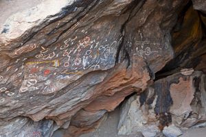
This rest area is also home to a remarkable petroglyph site.

Austin, Nevada

slgwv profile photo
Added By
slgwv
Email
Been Here
Want to go
Added to list
CAPTION
Close-up of elaborate petroglyphs by campground.   slgwv / Atlas Obscura User
Petroglyphs off the interpretive trail.   slgwv / Atlas Obscura User
Block with elaborate petroglyph panel near campground.   slgwv / Atlas Obscura User
View westward from the summit reached by the scenic trail. This is the area where the long loop trails are.   slgwv / Atlas Obscura User
View south from scenic trail to summit.   slgwv / Atlas Obscura User
View eastward from scenic trail to summit. Campground below, with the access road from US-50 visible.   slgwv / Atlas Obscura User
View from lower scenic trail. The scenic trail running to the summit on the left is visible on the open sagebrush slope skyline.   slgwv / Atlas Obscura User
Petroglyphs off the interpretive trail.   slgwv / Atlas Obscura User
Petroglyphs off trail.   slgwv / Atlas Obscura User
Been Here
Want to go
Added to list

About

About 24 miles east of Austin, Nevada, the "Loneliest Road" crosses Hickison Summit, a relatively low pass separating the Simpson Park Mountains to the north from the Toquima Range to the south.

It is the site of a rest area and campground, located less than a mile off the highway, as well as several well-preserved petroglyphs. An ADA-accessible interpretive trail runs by the petroglyph sites, and a couple of short scenic trails provide views of the surrounding area.

In addition, a trailhead about 1/3 mile north of the campground gives access to several loop trails, each several miles long and maintained by the Bureau of Land Management. These are open to horse traffic, as well as hikers.


Places

Discover your next amazing Atlas Place.

Get more unusual and extraordinary places each week with the Atlas Obscura Places newsletter.

Your newsletter subscriptions with us are subject to Atlas Obscura's Privacy Policy and Terms of Use.

Know Before You Go

The turnoff to the campground and interpretive site is well-marked. It's just east of the summit, where a graded access road runs for less than a mile to the west of US-50.

There are vault toilets at the picnic site, as well as at the campground. However, there is no water or electrical hookups, and cell phone service is nonexistent. The nearest supplies are in Austin or Eureka.

Community Contributors

slgwv profile photo

Added By

slgwv

Published

July 20, 2022

Edit this listing

Make an Edit
Add Photos

Related Tags

History & Culture Petroglyphs Trails
Hickison Summit
Austin, Nevada
United States
39.449317, -116.751881
Visit Website

Nearby Places

U.S. Route 50

Austin, Nevada

miles away

Stokes Castle

Austin, Nevada

miles away

Toquima Cave

Austin, Nevada

miles away

Explore the Destination Guide

Photo of Austin

Austin

Nevada

Places 7

Nearby Places

U.S. Route 50

Austin, Nevada

miles away

Stokes Castle

Austin, Nevada

miles away

Toquima Cave

Austin, Nevada

miles away

Explore the Destination Guide

Photo of Austin

Austin

Nevada

Places 7

Related Stories and Lists

Where to Experience the Best of Nevada’s Public Lands

nature

Sponsored By Travel Nevada

Related Places

  • McConkie Ranch Petroglyphs

    Vernal, Utah

    McConkie Ranch Petroglyphs

    A unique collection of drawings that represent Fremont Native American culture.

  • Dragonfly Trail Petroglyphs

    Silver City, New Mexico

    Dragonfly Trail Petroglyphs

    Hidden in the Chihuahuan Desert resides an amazing collection of petroglyphs.

  • The Red Cardinal Petroglyph

    Phippsburg, Maine

    Wild Bird Petroglyph

    A collection of modern petroglyphs by artist Kevin Sudeith. Hate them or love them, but important to experience.

  • Approaching the tower

    Barbate, Spain

    Torre Del Tajo

    This 16th-century watchtower once defended Spain's Atlantic coast from pirates.

  • Cairn T

    Ballineale, Ireland

    Loughcrew Cairns

    These Neolithic burial mounds and a still-intact passage tomb may have solar calendar significance on the spring and autumn equinoxes.

  • The entrance is overgrown and largely hidden.

    Kamakura, Japan

    Yatozaka Kiridoshi Pass

    An ancient mountain-cut pass runs largely forgotten in the suburbs of Kamakura.

  • Some of the rock art  in the site

    Taghit, Algeria

    Taghit Petroglyphs

    A set of ancient rock engravings that date back to the Neolithic period.

  • Salt Cave

    Fallon, Nevada

    Salt Cave

    Red ocher pictographs survive in this tufa rock shelter on the shore of an ancient lake.

Aerial image of Vietnam, displaying the picturesque rice terraces, characterized by their layered, verdant fields.
Atlas Obscura Membership

Become an Atlas Obscura Member


Join our community of curious explorers.

Become a Member

Get Our Email Newsletter

Follow Us

Facebook YouTube TikTok Instagram Pinterest RSS Feed

Get the app

Download the App
Download on the Apple App Store Get it on Google Play
  • All Places
  • Latest Places
  • Most Popular
  • Places to Eat
  • Random
  • Nearby
  • Add a Place
  • Stories
  • Food & Drink
  • Itineraries
  • Lists
  • Video
  • Podcast
  • Newsletters
  • All Trips
  • Membership
  • Feedback & Ideas
  • Community Guidelines
  • Product Blog
  • Unique Gifts
  • Work With Us
  • About
  • FAQ
  • Advertise With Us
  • Advertising Guidelines
  • Privacy Policy
  • Cookie Policy
  • Terms of Use
Atlas Obscura

© 2026 Atlas Obscura. All Rights Reserved.